Light snow as Shropshire wakes up to freezing temperatures
Brrr! Shropshire woke up to freezing temperatures and light snow today.
Flurries fell across the county with large flakes in Telford, despite bright sunshine.
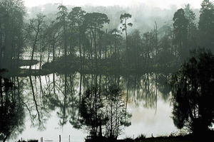
Mist could be seen rising off the water at Kettle Mere, Ellesmere, amid clear skies as the mercury plummeted to lows of -4 (24.8F) in parts of the county. Shawbury in north Shropshire was forecast to be the fourth coldest place in Britain for the next 24 hours.
A strong north-easterly wind is making temperatures feel even colder, possibly as cool as -10C (14F), and light snow showers were due across the West Midlands over the next 48 hours.
South Shropshire and Powys in Mid Wales are most likely to see snow.
There was a dusting over the south Shropshire hills over the weekend.
The southern counties of England are expected to take the brunt of heavy, repeated snow showers moving in from the south west, followed by a second band of wintry weather which will hit eastern and central parts of Scotland and England. But forecasters said there was a potential for a dusting of snow in all areas.
Up to 10cms (3.9 inches) will settle in the worst affected areas, including Kent, Sussex and southern Hampshire, as well as over higher ground in areas like the Pennines, while large areas could see around up to 4cm accumulate.
The cold snap will stay for most of the week but by Thursday most temperatures will creep above freezing again in Shropshire. Forecaster James Wilby said: "The snow will sporadic, areas only 10 miles apart will see big differences from heavy snow fall to no snowfall."