


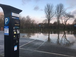
Frankwell car park in Shrewsbury is partially reopen, although the short stay area remains shut, with the Environment Agency retaining the lower height flood barriers.
Barriers will not be put in place at Ironbridge, agency staff say.
There is still one flood warning in the county, for the River Severn at the Shrewsbury Showground and The Quarry, with lower flood alerts for the Severn across Shropshire and the Severn Vyrnwy confluence.
Across the Welsh border there is a flood warning for the River Dee below Llangollen.
Shrewsbury Police has today warned people on social media that road closures remain in place as the river level is still rising in Sydney Avenue.
River still rising in Sydney Avenue in shrewsbury. Road closure in place. Take care all road usesrs! #RoadSafety pic.twitter.com/qh0GPLrfMY
— Shrewsbury Police (@ShrewsburyCops) February 12, 2020
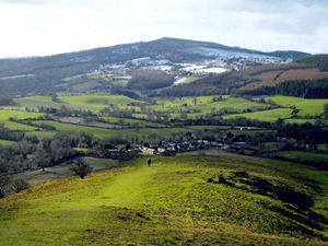
Wintry showers have led to snow settling on high ground in the region including on the hills above Oswestry and at Earls Hill, Pontesbury, where keen photographer, Dave Evans captured the scene on camera yesterday.
"It was the coldest I have known up on the hill, because of the wind," he said.
At Llangollen the Ponderosa cafe on the Horseshoe Pass was closed yesterday because of snow and ice but the owners said they were hoping to reopen today.
Weather forecasters say rain will return tonight, but say the main problems will be on Saturday and Sunday when another deep low, storm Dennis, hits the UK.
Watch today's weather forecast:
Across the country snow and ice could cause travel disruption today before Britain is struck by another burst of heavy rain and gales from Storm Dennis over the weekend.
Cumbria, Northumberland and vast swathes of Scotland have been warned of “blizzard conditions” by the Met Office as snow showers are combined with strong winds.
#StormDennis could be a troublemaker this weekend.
— Dave Throup (@DaveThroupEA) February 12, 2020
Wind gusts up to 60mph again and a lot of rain where it’s not wanted.
Rivers are already full and significant flood impacts are possible.#floodaware pic.twitter.com/Gd1G9ZdACk
The regions are subject of a yellow weather warning with up to 10cm of snow forecast in higher parts, while Northern Ireland could see further snow showers, forecasters said.
Tuesday was another cold ? and windy ?️ day with a mixture of sunshine and showers for most
There was further snow for some, particularly in the north ⛄️ pic.twitter.com/MK9W3vZlAZ
— Met Office (@metoffice) February 11, 2020
The fourth named storm of the 2019-20 season, Dennis, is set to bring a second consecutive weekend of wet and windy weather after Ciara struck the UK with winds of up to 97mph.
Gusts of 50mph are expected, with more than 60mph possible over hills, coastal areas and exposed locations, the Met Office said.
Predicted heavy rain could also run the risk of further flooding, with 43 warnings still in place in England, six in Scotland and one in Wales following recent heavy rainfall.
Around 730 properties are believed to have been affected by flooding in recent days, the Environment Agency said as it warned of more wet weather ahead when Dennis takes hold.
There'll still be some #snow showers and icy stretches around in parts of the north for the morning commute.
Further south it will be mostly dry but with a touch of #frost.
Travel safe, stay #WeatherAware pic.twitter.com/CNQdgGMNAK
— Met Office (@metoffice) February 11, 2020
Caroline Douglass, flood duty manager at the agency, said: “River and surface water flooding is possible on Saturday into Sunday due to Storm Dennis and we are advising people to check their flood risk and to stay safe on the coast or when walking or driving near swollen rivers.”
She also warned people against taking “dangerous” so-called storm selfies.
Chief meteorologist Steve Ramsdale said: “Another spell of very wet and windy weather is expected for Saturday.
“Although Storm Dennis is currently not expected to be as severe as Ciara, disruption is still likely.”