Flood barriers sent to Ironbridge but not expected to go up yet as river levels subside elsewhere
Flood barriers are being delivered to Ironbridge but are not expected to be put up this weekend as high river levels subside in other parts of the county.
The issue of flooding has had Salopians concerned again this week after three disastrous River Severn floods in two years recently.
Telford & Wrekin Council has confirmed barriers are being sent to Ironbridge but are not expected to go up today or Sunday. In Shrewsbury, the flood warning at West Mid Showground has been removed and an Environment Agency expert said the peak has passed through the town.
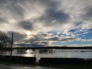
Further up the river, near Edgerley west of Nesscliffe, fields in the vicinity of the river have been flooded out.
In Shropshire, there is one flood warning in place - in Frankwell, Shrewsbury - and six less serious flood alerts. The warning for the West Mid Showground was removed at 12.06pm today.
The latest flood warning for Frankwell in Shrewsbury said: "Flooding is possible in this area. Monitor local water levels and weather conditions. Avoid using low-lying footpaths or entering areas prone to flooding. Start acting on your flood plan if you have one.
"As the Frankwell barriers have been deployed and are fully operational, we are currently not expecting protected properties in this area to be impacted. The Environment Agency Flood Warning System has issued this message based on rising river or tidal levels."
Areas where flood alerts are in place include Rea Brook and Cound Brook, the River Dee catchment from Whitchurch to Chester, the Severn Vyrnwy confluence, the Tern and Perry catchments, the Upper Teme and the River Severn in Shropshire.
A Telford & Wrekin Council spokeswoman confirmed the delivery of the barriers to Ironbridge and added: "We’ve delivered sandbags to the area for residents to collect from today if they are concerned and all of the businesses remain open as usual."
Rob Davies, hydrometry and telemetry officer for the Environment Agency, said: "The River Severn in Shrewsbury - thankfully the peak has now passed through but there are still flood warnings in place and rain around in coming days."
The Met Office's weather forecast for the region predicts further showers through the weekend: "Showers continuing during the evening, potentially thundery, before petering out later in the night to allow for some clearer spells. A little chillier than recent nights but remaining frost-free. Minimum temperature 5C.
"A bright start to Sunday morning, however further blustery showers will soon arrive, these locally heavy and potentially thundery. This mixture of sunshine and showers continuing through the day. Breezy. Maximum temperature 8C.
"Outlook for Monday to Wednesday: remaining unsettled into next week with further showers and strong winds. Particularly wet and drab on Tuesday as more persistent rain pushes through, but also feeling milder."