These Nasa images show just how Hurricane Irma drastically changed the Caribbean islands
Lush green lands have turned almost completely brown.
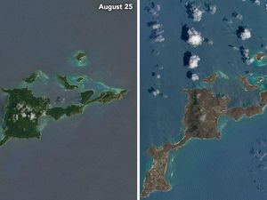
The Caribbean islands were the first to be hit by Hurricane Irma, a category five storm, killing 30 people and making many homeless before wreaking devastation in the United States and Cuba.
As it passed over the islands and the clouds cleared, Nasa noticed a rather drastic change.
Comparing with images that were taken just days before the storm, the US space agency noticed the islands had changed colour, from lush green to bare brown.
The images were taken by Nasa’s Operational Land Imager instrument aboard the Landsat 8 satellite on August 25 and then on September 10.

“There are a number of possible reasons for this. Lush green tropical vegetation can be ripped away by a storm’s strong winds, leaving the satellite with a view of more bare ground.

Nasa also noted that some of the vegetation on the west side of Virgin Gorda remained because it was in area partially sheltered by hills in the centre of that island.

Explaining why the ocean colours were different, Nasa wrote: “Differences in ocean colour likely stem from differences in the ocean surface; rougher surfaces scatter more light, and appear brighter and lighter.”

It says the last time the network was brought online was during the Ecuador earthquake in 2016, where citizen scientists analysed “almost 25,000 square kilometres of satellite imagery in only 12 hours”.