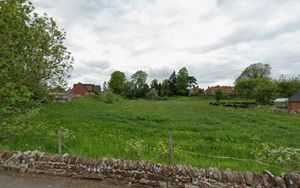
This is a lifesaving asset': Plans for homes on field near Newport used for air ambulance landings thrown out
Councillors have rejected plans to build new homes on a field that has been used for air ambulance landings.
Outline permission was sought for up to 19 new homes to be built on the land between Newport Road and Wharf Road, known locally as Stacey’s Field, in Gnosall near Newport.
The application also proposed the conversion of an existing barn into a house. But the proposals were recommended for refusal by planning officers at Stafford Borough Council for reasons including highway safety risks and loss of green infrastructure.
The application was referred to the council’s planning committee for consideration because it “raises unusual issues of planning policy”. At a planning committee meeting on November 19, members unanimously voted to refuse permission for the development.
The borough council received 68 objections to the application. Objectors highlighted flood issues on the site and surrounding roads, as well as existing demand on local amenities such as schools and health services.
Alan Monahan, who spoke against the application at Wednesday’s meeting, said: “The central flat area [of the field] is still cut and baled for hay, preserving a traditional rural use. It also helps to alleviate the already major flooding issues on two adjacent roads.
“The field’s presence is of great importance to the community and its loss would be profoundly damaging to the village’s rural character. Building on it would irreversibly erode the identity and character of the landscape.
“How can just 20 properties justify such a loss? Many local residents even doubt whether such a number could realistically or sensitively fit within this constrained site.
“The field has also served for years as a crucial air ambulance site. Development would remove this lifesaving asset and could delay emergency responses at moments where every second counts.
“The proposed access from the A518 Newport Road raises serious safety issues. This busy route has limited visibility, with heavy traffic for most of the day.”
Agent Jon Imber, who spoke in support of the application, said the proposals had been revised however, reducing the number of planned new-build homes to 17. He added: “The revised plans also incorporate a path to the access road and move development away from the area identified as being at risk of surface water flooding.
“Your planning officers accept that the case is finely balanced. What’s not mentioned in the report is that we have submitted revised plans to address the highway authority’s concerns, as well as the concerns of the lead local flood authority.
“The council currently has a significant shortfall in housing land supply, falling well below the five years required by the Government. This means the presumption in favour of sustainable development is triggered and development should only be refused if harm associated with it significantly and demonstrably outweighs the benefits.
“Whilst the scheme would result in the loss of green infrastructure, it is important to note that there is no public access to it. It does not therefore perform any function above and beyond that performed by greenfield land in general.
“The council is likely to come under significant pressure from housing developers to release swathes of countryside on the edges of settlements. Unless windfall sites like this are allowed, there is a very real risk that future growth in the district will be determined by appeal decisions as opposed to the formal planning process.”
You can find out more about planning applications and planned roadworks where you live by visiting publicnoticeportal.uk.