Shropshire flood alerts: Partial closure at Shrewsbury's Frankwell car park
Part of Frankwell car park in Shrewsbury was closed on Monday to allow for flood barriers to be installed along the River Severn.
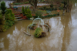
Footpaths along the Severn have been closed for several days after the river burst its banks and around 160 spaces are now out of action at the Riverside car park in Frankwell.
No barriers have been put up in Ironbridge but several flood alerts remain in place across the county and neighbouring areas due to heavy rainfall.
The Environment Agency said it was closely monitoring the situation.
Shropshire Council posted on Twitter: "Frankwell Riverside Car Park is closed due to occupation by our partner the Environment Agency.
"Frankwell main car park 'floods expected' sign out - partially closed with area for customers not to park within - set out with traffic cones. Loss of about 160 spaces."
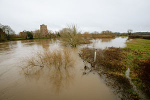
The River Severn in various locations, the Upper Teme near Ludlow, the River Worfe near Albrighton and the Severn Vyrnwy confluence near Oswestry are all carrying alerts on the government's flood warning information service, although the Environment Agency is reporting that levels are falling in some areas.
Forecast
At the Severn Vyrnwy confluence there may be flooding from the Welsh border at Llawnt to Shrawardine near Shrewsbury. Other locations that may be affected include Llanymynech, Maesbrook and Melverley. With further rainfall forecast over the next 24 hour levels are expected to remain high for several days.
Levels have risen at the Buildwas gauge and experts expect flooding to affect low lying land and roads adjacent to the river from Shrewsbury to Upper Arley. Locations that may be affected are Coalbrookdale, Ironbridge and Bridgnorth.
River levels remain high at Upper Teme, but are falling at the Leintwardine and Onibury river gauges. Locations that may be affected include Bishops Castle, Church Stretton, Knighton and Ludlow. Here further light rainfall is forecast over the next 24 hours and river levels are expected to remain high over the next few days
River Worfe levels are also slowly falling at the Burcote and Cosford river gauges with flooding expected to affect low lying land and roads from Crackley Bank to Bridgnorth.
A flood alert is also in force at the River Dee catchment from Whitchurch to Chester.
Peak levels include Welsh Bridge in Shrewsbury at up to 3.2m by Monday afternoon, Buildwas up to 4.4m on Tuesday morning and Bridgnorth up to 3.5m 3.3 to 3.5m on also on Tuesday.
A spokesman from Shropshire Fire and Rescue Service said: " Do not attempt to drive through flooded roads or fords and do not attempt to walk through flooded areas.
"Children should not be allowed to play in flood water, due to contamination. Keep an eye on weather reports on local television or radio channels and look after your neighbours."