Shropshire set for 13C as wintry weather is due to end, according to the Met Office - here's when
The wet and wintry conditions that have swept across the Shropshire this week are expected to ease with the Met Office forecasting temperatures of up to 13C - here's when
Today:
Outbreaks of rain, sleet and snow should gradually peter out in the morning, perhaps allowing skies to brighten from the northwest heading into the afternoon. Remaining chilly, though with winds easing. Maximum temperature 5 °C.
Tonight:
Largely dry this evening and overnight with occasional clear spells. A slight breeze picking up from the west, otherwise still chilly. Minimum temperature 2 °C.
Friday:
Cloudy with further spells of rain pushing in from the west through the morning, followed by blustery showers into the afternoon. Much milder. Maximum temperature 11 °C.
Outlook for Saturday to Monday:
Often cloudy with outbreaks of rain or showers, these heavy at times. Much milder than recent days though, and feeling pleasant in any sunny breaks that may develop. Windy.
The wet and wintry conditions that have swept across the Shropshire this week are expected to ease on Thursday, with forecasters predicting a much milder feel across Shropshire by the weekend.
Three yellow weather warnings issued by the Met Office — including alerts for snow across parts of the West Midlands and heavy rain further south — are due to expire on Thursday morning.
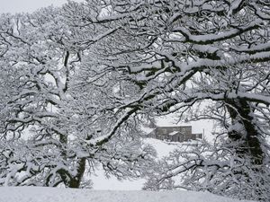
Parts of Shropshire, including Shrewsbury, Telford, Oswestry and Ludlow, have seen spells of rain, sleet and occasional snow over recent days, making for difficult driving conditions and standing water on some roads.

According to forecasters, Thursday will start cloudy and damp, with outbreaks of rain and sleet gradually clearing through the morning. Brighter intervals are expected to develop into the afternoon as winds ease. Daytime temperatures will remain cool, reaching around 5C to 7C, with a risk of patchy frost or icy stretches early on untreated surfaces.
Friday is set to bring a mixture of sunny spells and scattered showers. It will be a chilly start in rural areas, but milder Atlantic air will begin to push in from the west during the day, lifting temperatures slightly compared with earlier in the week.
Saturday is expected to be largely cloudy across the county, with outbreaks of light rain or drizzle at times, particularly in western and central areas. There may be occasional brighter spells, but much of the day is likely to feel overcast and damp rather than dry and settled.
Temperatures are forecast to reach around 12C to 13C during the afternoon — noticeably milder than earlier in the week.
The changeable theme continues into Sunday, with further spells of rain moving through at times. Cloud is expected to dominate, although some drier intervals are possible between bands of rain. Daytime temperatures are set to remain in the low teens.
While the worst of the recent wintry weather has eased, the outlook suggests Shropshire will see a typical unsettled February weekend, with residents advised to check for updates before making outdoor plans.
Met Office weather forecast
Today:
Outbreaks of rain, sleet and snow should gradually peter out in the morning, perhaps allowing skies to brighten from the northwest heading into the afternoon. Remaining chilly, though with winds easing. Maximum temperature 5 °C.
Tonight:
Largely dry this evening and overnight with occasional clear spells. A slight breeze picking up from the west, otherwise still chilly. Minimum temperature 2 °C.
Friday:
Cloudy with further spells of rain pushing in from the west through the morning, followed by blustery showers into the afternoon. Much milder. Maximum temperature 11 °C.
Outlook for Saturday to Monday:
Often cloudy with outbreaks of rain or showers, these heavy at times. Much milder than recent days though, and feeling pleasant in any sunny breaks that may develop. Windy, as temperatures could reach 13C