Yellow weather warning issued for the West Midlands on Wednesday by the Met Office - latest advice here
The Met Office has issued a yellow warning covering the West Midlands on Wednesday morning- full details here
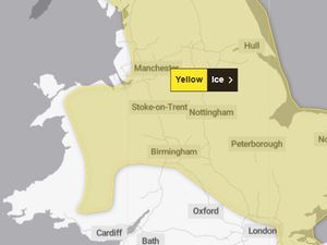
The Met Office yellow weather warning, which covers most of the West Midlands, warns that patchy ice is likely to form on untreated surfaces on Wednesday, January 28 morning and may lead to some disruption.
Clearing skies saw temperatures fall below freezing overnight, and after the recent wet weather, icy patches are likely to develop on some untreated surfaces.
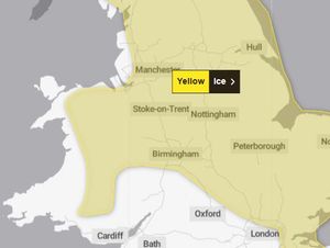
The warning is rated low for potential impact, and medium for the likelihood of ice being present. The Met Office have the yellow warning in place until 10am.
A warning from the Met Office reads: "Keep yourself and your family safe when it is icy. Plan to leave the house at least five minutes earlier than normal. Not needing to rush, reduces your risk of accidents, slips, and falls.
"If you need to make a journey on foot, try to use pavements along main roads which are likely to be less slippery. Similarly, if cycling, try and stick to main roads which are more likely to have been treated.
"Give yourself the best chance of avoiding delays by checking road conditions if driving, or bus and train timetables, amending your travel plans if necessary.
"Be prepared for weather warnings to change: when a weather warning is issued, the Met Office recommends staying up to date with the weather forecast in your area."
Met Office weather forecast
Today:
Any fog patches clearing mid to late-morning. Otherwise a much drier and brighter day with sunny spells. Isolated showers possible. Feeling more pleasant too with light and variable winds. Maximum temperature 8 °C.
Tonight:
Largely dry overnight, but fog and low cloud becoming extensive, particularly across the east of the region. Clearer breaks holding on across western counties with some frost possible by dawn. Minimum temperature -1 °C.
Thursday:
A mainly dry but largely cloudy day with any fog slowly lifting into low cloud during the morning, the best of any brighter spells reserved for Shropshire and Herefordshire. Maximum temperature 8 °C.
Outlook for Friday to Sunday:
Staying changeable with rain or showers, with Friday probably the wettest day. Longer drier periods over the weekend with occasional sunnier periods. Temperatures close to average. Breezy at times.