Flood warnings in place as Storm Chandra brings heavy rain and strong winds to Shropshire
Residents across the region have been warned of the possibility of disruption throughout the day as Storm Chandra makes an impact.
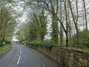
Two flood warnings are in place in the south of the county at the borders with Worcestershire and Herefordshire, while nine flood alerts have been put up by the Government flooding service as Storm Chandra brought a night of heavy rain.
Residents living near Brimfield Brook at Orleton and Brimfield and River Teme at Stanford Bridge have been warned to expect flooding as river levels continue to rise in both areas.
The Flood Service said for Brimfield Brook at Orleton and Brimfield: "Rising river levels are expected to cause flooding today.
"Flooding may affect properties around the Brooklets, Wyson and Brimfield.
"We are closely monitoring the situation .
"Take care and avoid walking, cycling or driving through flood water . Start acting on your flood plan if you have one.
"The Mill Brook level at Orleton Millbrook Way was 0.56 metres. Property flooding is possible when it goes above 0.65 metres."
The Flood Service said for River Teme at Stanford Bridge: "Rising river levels are expected to cause flooding today.
"Flooding may affect properties and roads in and around Stanford Bridge.
"We are closely monitoring the situation.
"Start acting on your flood plan if you have one and take care and avoid walking, cycling or driving through flood water.
"The River Teme level at Tenbury was 2.66 metres. Property flooding is possible when it goes above 3.40 metres.
"The River Teme level at Stanford Bridge was 2.71 metres. Property flooding is possible when it goes above 3.70 metres."
The alerts have been put in place at Brooks in the Wyre Forest, Ledwyche Brook and River Rea, Lower Teme, Rea Brook and Cound Brook, River Lugg North of Leominster, River Worfe, Severn Vyrnwy confluence, Tern and Perry catchments and Upper Teme, with all alerts in place until 11am.
For Brooks in the Wyre Forest, flooding may affect low lying land and roads adjacent to the river from Acton Round to Noutards Green. Other locations that may be affected include Morville, Eardington, Highley, Wribbenhall and Rock, while for Ledwyche Brook and River Rea, flooding may affect low lying land and roads adjacent to the Ledyche Brook and River Rea. Locations that may be affected include Cleobury Mortimer, Neen Sollars and Caynham.
For Lower Teme, flooding may affect low lying land and roads adjacent to the River Teme from Ludlow to Bransford. Locations that may be affected include Wyson, Ludlow, Tenbury Wells and Knightwick, while for Rea Brook and Cound Brook, flooding may affect low lying land and roads adjacent to the river from Shrewsbury to Church Stretton. Other locations that may be affected include Minsterley, Pontesford and Harrington.
For River Lugg North of Leominster, flooding may affect low lying land and roads to the River Lugg north of Leominster. Locations that may be affected include Yarpole, Mortimers Cross, Kingsland and the B4362, while for River Worfe, flooding may affect low lying land and roads adjacent to the river from Crackley Bank to Bridgnorth. Other locations that may be affected include Ryton and Burcote. Water is rising in the drains at Worfield.
For Severn Vyrnwy confluence, flooding may affect low lying land and roads adjacent to the river from the Welsh border at Llawnt to Shrawardine near Shrewsbury. Other locations that may be affected include Llanymynech, Maesbrook and Melverley. Roads between Maesbrook, Melverley and Pentre start to flood.
For Tern and Perry catchments, flooding may affect low lying land and roads adjacent to the river from Wolverley to Newport. Other locations that may be affected include Market Drayton, Wem, and Rodington and for Upper Teme, flooding may affect low lying land and roads adjacent the River Teme, River Onny and River Corve and their tributaries. Locations that may be affected include Bishops Castle, Church Stretton, Knighton and Ludlow.
A yellow warning for rain is in place from midnight until midday on Tuesday for much of south-east England, and for south-west England and south and central Wales from 1pm on Monday to 10am on Tuesday.
Met Office chief forecaster Paul Gundersen said: “Initially, strong winds will impact the Isles of Scilly, western Cornwall and south-west Wales which are still vulnerable after Storm Goretti, gusts of 70 to 80mph are possible here.
“Heavy rain is an additional hazard as it falls on saturated ground in Dorset and southern parts of Devon, Somerset and Cornwall.
“As Chandra interacts with colder air further north snow becomes a hazard, with 10-20cm of snow possibly accumulating over higher ground in the Pennines, southern Scotland and the Highlands.
“With a complex spell of weather, its important people stay up to date with the forecast and any warnings in your area.”
RAC mobile servicing and repairs team leader Nick Mullender said: “Flooding is highly likely, making many roads dangerous. Our message to drivers is simple: do not drive through standing water unless you are completely certain the water is shallow enough and it’s safe to do so.
“In these conditions, drivers need to slow down and stay alert. Wet roads can double stopping distances, so taking a cautious, steady approach and allowing extra time to react is essential.
“And if your vehicle already has known faults, now is not the time to take risks. Avoid unnecessary journeys and get issues fixed promptly by a trusted mobile mechanic or local garage.”
Storm Chandra is the next storm to be named by the western Europe storm naming group list shared between the UK, Ireland and Netherlands