Heatwave to take West Midlands temperatures as high as 27C within days
Get your suncream and sandals out – another heatwave is on the way.
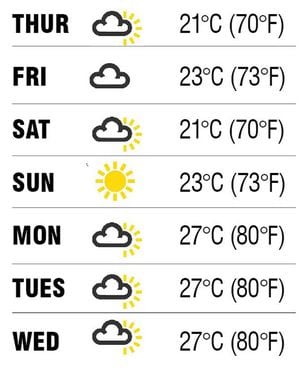
Temperatures are expected to top 80F in the West Midlands by the start of next week.
It is all thanks to a weather system known as a Bermuda High that is approaching us towards the end of the week.
Hot air originating in North Africa and travelling up through Spain is expected to bring us hot, dry conditions.
It will replace the unsettled patch we have experienced since a mini hot spell at the start of June.
James Madden, a forecaster for Exacta Weather, said: “We are about to see a period of very warm weather which could hold out for seven to 10 days and bring a major heatwave to Britain.”
The Met Office defines a heatwave as at least three consecutive days of temperatures above a certain level. The threshold is different for each county, depending on where they are in the country.
In London temperatures must breach 28C (82F) for three days in a row for there to be a heatwave, while in the West Midlands temperatures need to remain above 26C (79F).
Heatwaves are most common in summer when high pressure develops across an area. High-pressure systems are slow moving and can persist over an area for a prolonged period of time, such as days or weeks.
Our recent unsettled weather has coincided with the jet stream moving south. The fast flowing jet of air, which sits high in the atmosphere, dictates where weather systems move. If the jet streams move south, they force Atlantic wet fronts over the UK.
Forecasters say the jet stream has now moved north, taking any poor weather out of harm's way.
Mr Madden said: “When the jet stream moves north it allows high pressure to develop over the UK resulting in persistent dry and settled weather.”