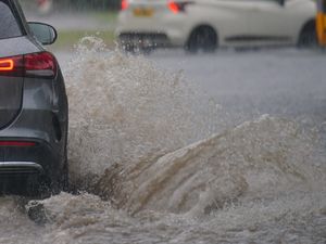
UK weather: Flood alert issued for Severn Vyrnwy confluence as heavy rain forecast
Watch the Met Office’s latest video forecast, as flood alerts are issued for parts of England.
A number of flood alerts have been issued for England, including for the Severn Vyrnwy confluence near Melverley.
The six flood alerts are in place for areas where ‘flooding is possible’.
The Government flood monitoring service said: "River levels are rising at the Llanymynech river gauge as a result of heavy rainfall. Consequently, flooding of roads and farmland is possible today (June 14).
"Flooding may affect low lying land and roads adjacent to the river from the Welsh border at Llawnt to Shrawardine near Shrewsbury. Other locations that may be affected include Llanymynech, Maesbrook and Melverley.
"Further rainfall is forecast over the next 48 hours. We expect river levels to remain high until Saturday afternoon (June 14).
"We are closely monitoring the situation. Our incident response staff are checking defences."
The six flood alerts
Mid Devon Rivers
North Dartmoor Rivers
Rivers Duddon, Crake and Mill Beck
Rivers Greta, St Johns Beck and Bassenthwaite Lake
Severn Vyrnwy confluence
Upper River Derwent, Stonethwaite Beck and Derwent Water
For more information on flood warnings and alerts visit GOV.UK.
West Midlands Met Office weather forecast
June 14 day
Widely cloudy with spells of heavy rain spreading northwards, carrying a risk of hail, gusty winds, and thunder. Some bright or sunny spells developing through the afternoon, interspersed with further heavy showers. Breezy, but still feeling warm. Maximum temperature 23 °C.
June 14 night
Showers fade away through this evening leaving a mostly dry night with clear spells developing. Feeling fresher in a westerly wind. Minimum temperature 12 °C.
June 15
A bright start with plenty of sunshine, but turning cloudier through the day with scattered showers developing during the afternoon, these heavy at times. Cooler with temperatures near average. Maximum temperature 22 °C.
June 16 to June 18
A generally drier and more settled period with plenty of sunny spells, and light patchy rain, mainly confined to the hills. Winds becoming light with temperatures closer to average.
Have you got a video you want to share with our readers? You can now send it to us online via YourWorld at https://www.yourworld.net/submit/ It's free to use and, once checked, your footage will appear on our website.