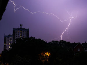
Thunderstorms and heavy rain expected across Shropshire as unpredictable June weather continues
Thunderstorms and several inches of rain are set to hit the county over the next three days, but high temperatures may also be on its way as well as the weather across the region remain unpredictable.
The Met Office said that on Thursday, it would be warm and humid day with thundery downpours.
Today:
A dry start, with showery outbreaks of heavy, possibly thundery rain clearing northeastwards through late morning and into the afternoon, followed by sunshine and thunderstorms, accompanied by gusty winds and hail, but feeling warm and humid and a maximum temperature of 24 °C.
Tonight:
On Thursday night, the thunderstorms are set to gradually ease during the evening to leave clearer spells into the night and mostly dry conditions, as well as winds easing but remaining warm and muggy overnight and a minimum temperature of 11 °C.
Friday:
Friday will be largely dry by day with occasional brighter spells and the odd shower, with the Met Office saying these would be generally lighter than recent days, but heavier, thundery rain would be arriving during the evening and it would be very warm and humid, with a maximum temperature 27 °C.
Saturday to Monday:
Finally, the Met Office said the outlook for Saturday to Monday was for heavy rain and thunderstorms on Saturday with hail and gusty winds, but easing on Sunday to leave a largely dry day with bright spells on Monday and feeling fresher.
A map on the Met Office website also predicted that some areas may see about 16 inches of rain in a few hours and winds of up to 27mph between today and Saturday, while temperatures could go as high as 25°C (77°F) in parts of the region.
Met Office Chief Meteorologist Neil Armstrong said, “A weather system will push northwards through tomorrow, bringing heavy rain and a risk of thunderstorms to parts of southwest England, most of Wales, and later into Northern Ireland.

"40mm of rain could fall in 3 hours or less leading to the potential for disruption. Further thunderstorms will develop during the afternoon across England and Wales, moving quickly northwards with hail and lightning.
"Temperatures will remain high, with 26 or 27°C possible again in the north Midlands and parts of north London."