'Threat to life' warning for Ironbridge as 40 evacuated amid fears river may reach 'unprecedented' levels
A 'danger to life' flood warning remains in place for Ironbridge today, as police warned there is now 'a strong possibility water could over top the temporary flood barriers currently in place'.
About 40 people in affected areas have been asked to evacuate, with police warning 'unprecedented' levels may put authorities in a position where they are unable to rescue residents.
The river is expected to peak in the early hours of Wednesday morning.
West Mercia Police Chief Superintendent Tom Harding said: “The levels of the river in Ironbridge are set to rise to unprecedented levels with a strong chance they could overtop the temporary flood barriers.
"Our absolute priority is the safety of local residents and we would strongly advise those who live in the affected area to evacuate, we know people don’t want to leave their homes but we are only giving this advice as we believe it is absolutely necessary.
“We are working very closely with our emergency response partners to ensure plans are in place should the water overtop the barrier however at the moment we don’t know what impact that will have but my warning is we may be in a position where we can’t rescue residents who don’t leave their home.”
A rest centre for any residents affected is open 24/7 at the Tontine Hotel in Ironbridge. Hotel accommodation is available for any residents who leave their home.
See also:
Coalbrookdale Primary school is closed today and will be closed tomorrow.
Telford & Wrekin Council said: "We ask that everyone avoids the area as it is not safe and we do not want anything to hinder the hard work of the teams on the ground.
"Please help and look out for others in the local community if you can especially the elderly and vulnerable.
"We have done all we can to help and now we just need to pull together and support those who need some assistance.
"Thank you for your cooperation and as always please make anyone you need to aware of these important messages."
The Environment Agency said it expected river levels to stay high throughout the week, and that it was closely monitoring the situation.
"Our incident response staff are liaising with emergency services regarding the temporary flood barriers at Ironbridge," it said.
"Please move possessions and valuables to safety and have a bag ready with vital items like medicines and insurance documents. Please follow advice from emergency services."
Meanwhile, a waterlogged pitch has caused tonight's National League North against Curzon Ashton to be postponed, says AFC Telford United.
"A new date will now be arranged at a later date to allow as much time as possible for the pitch to dry out," said the team.
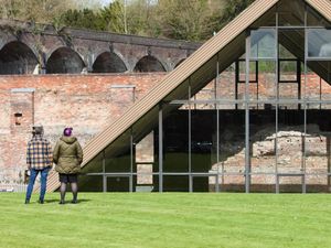
Flood tourists
Emergency services, representatives of the council and of utility companies were also out in force, filling the usually busy stretch of road along the Severn with ambulances, police cars and work vans.
Ian Kelly and Maggie O'Toole, of Hilltop, were taking a morning walk along Severn Bank, the floods providing an unusual backdrop for Ian's 70th birthday.
He said he wouldn't be going far because of the rising water – although it had stopped him from going for a ride on his bike.
"It's because of global warming I expect," he said. "People who've lived here all their lives tell us that it used to flood very badly, and they put in control measures higher up. It has gradually got worse again."
And although the river made for an impressive sight, Ian said when the barriers were first brought in, there was less protection for those on the dry side of them.
"When they first started to use the barriers, you could get right up to them," he said. "I remember climbing up it and you could reach over and touch the river."
Peter James, 82, has lived in the area for 60 years and said it was the worst he'd ever seen it.
"The river hasn't been dredged. I think that's the biggest problem. I fished the river many years ago and I was going down 20 feet. You're lucky if you get down 12 feet.
"I live pretty high up, but I've got friends who live along the flooded bank, and this is the second time it's happened. He's lost a hell of a lot of money.
"All the flood defences do is transfer it somewhere else. They need to stop building on flood planes. The idea of farmers providing fields to be flooded is a good thing to make new flood planes."
Mr James said the discussion of better flood defences would disappear once the river had gone back down.
"The only time you see politicians about is when they come and take a quick look and they disappear," he said. "That's the last you hear of it.
"I think they'll forget about it when the river comes back down."
Gardener and self-confessed weather buff Julie Day and her husband Michael travelled from Posenhall to see the floods.
"We're seen it at this level before, but usually it's melt water from snow," Julie said. "We last saw it at this height in 2000.
"There's a polar vortex at the moment – the arctic is really cold, so it's keeping the jetstream just pouring in all the time. That's why we're getting the rain.
"Quite often at this time of year we get easterlies, which stay dry. This time two years ago we got the Beast from the East and we were all up in snow and ice," she said. "It's dependent on the weather systems of the world – we're not in isolation."
Julie said power station owners Harworth need to pay attention to the current floods as part of their plans.
"If you think they're building the houses on the fields, not directly on the power station site, and you're going to have all that run off. It'll go straight into the river and you've already got these levels. There's no way that isn't going to make things worse."
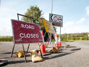
Road closures
The following roads are closed due to flooding:
Wharfage (also closed to pedestrians)
Dale End
Buildwas Rd
The Lloyds
Coalford/Lloyds Head
Waterloo St
Madeley Rd
Ironbridge Rd
Ferry Rd
Madeley Road from Hill Top
Church Hill
The Free Bridge – There is no access to Broseley from Ironbridge and Jackfield
Paradise
Church Hill