Storms: Shrewsbury flood barriers go up as venues close and events called off
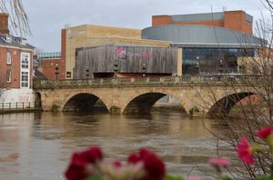
The first line of Shrewsbury's flood defences is going up in readiness for potentially high water levels caused by two storms that are about to hit the UK.
Shropshire Council said it had been notified by the Environment Agency that the barriers at Frankwell will remain in place until further notice, to protect the area from flood water from the River Severn.
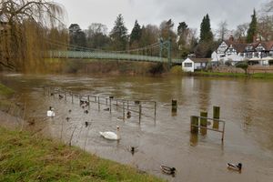
Flood alerts remains in place on the river throughout Shropshire, while a yellow wind warning is in place from 1pm on Wednesday until 6am on Thursday, followed by an amber warning on Friday from 3am-9pm.
The water is expected to peak at Montford Bridge on Thursday morning, at Shrewsbury's Welsh Bridge on Thursday evening and then at Buildwas and Bridgnorth on Friday. There are also alerts on the Upper Teme, the Tern and Perry catchments, the Rea and Cound Brooks and the Ledwyche Brook and River Rea.
Chris Bainger, an officer with the Environment Agency, said the deployment of flood barriers at Frankwell was more a precaution at this stage.
"It's about thinking big and acting early," he said. "With high winds forecast it would be more difficult to put the flood barrier up at Frankwell.
"River levels are high but that is not unexpected at this time of the year. We are expecting levels to continue to rise."
The agency is forecasting the peak at Welsh Bridge to reach between 2.7m to 3.2m on Thursday evening.
A spokesperson for the Environment Agency added: "Further heavy rain is forecast over the week with, heavy rainfall predicted for Friday overnight which may cause further rises in river levels.
"We expect river levels to remain high over the weekend. We are closely monitoring the situation. Please avoid using low lying footpaths near local watercourses and avoid contact with flood water."
Business owners in the county town are so far not concerned about the weather.
Sam Jewell at House Coffee in Longden Coleham said: "We know when we need to worry, and that's when it reaches 4.5m at Welsh Bridge."
Ollie Parry, a co-owner of the Salopian bar, added: "If it floods the Frankwell car park then we will get water bubbling up in the old cellar.
"I'm not worried at this stage. Our cellar has flooded 50 times in the last 16 years but floodwater has only come across Smithfield Road twice in that time."
Mr Parry reckons there has not been enough rain to make it a major flooding event.
"We need to have it rain like it did on Monday for three or four days. I will be shocked if it becomes a problem," he added.
James Hitchin, at The Alb, said: "I would rather have it flooding than go through covid again.
"My concern is when it gets to four metres when we have a problem but the current forecast is between 2.3m and up to three."
Barriers have also been installed downstream at Bewdley.
The Attingham Park estate will also close its gates early today and batten down the hatches as winds increase.
Other National Trust properties in the area, Chirk Castle and Erddig Hall on the Welsh border, have already closed.
Staff at all three sites are warning people to check before their travel for the rest of the week to see if the properties are open.
A spokesperson for Attingham Park, near Shrewsbury, said the property would close to all visitors on Wednesday from 2.30pm until at least 9am on Thursday "for the safety of visitors and staff and volunteers."
"We anticipate that the forecasted wind speeds will lead to trees and branches down across the estate affecting visitor access and safety. Once safe to do so our team will begin clearing the site to re-open as soon as possible.
"We plan to re-open on Thursday but will be keeping an eye on the upcoming weather as it develops over the next few days and through the weekend. We will provide updates through our social channels and our webpage. We’re sorry for the disappointment this will cause."
Staff at both Chirk Castle and Erddig Hall have urged people not to walk on the estate grounds because of the threat from falling branches.
Telford & Wrekin Council has warned residents of fallen trees on roads and footpaths, and to even be prepared for potential snowfall.
A council statement said: "Telford and Wrekin Council's building control, highways and tree teams will all be on hand should any incidents occur such as damage to buildings caused by high winds that pose a risk to the public.
"There is uncertainty over the strength of the winds and the worst-affected areas, the Met Office said.
"This system is also expected to bring some heavy rain and there is a potential for some significant snowfall over hills in the Midlands and further north."
Councillor Lee Carter, the cabinet member for neighbourhood services, regeneration and the high street, added: “Our crews will be on hand ready to help with damage caused by high winds or any localised surface water flooding should this occur.
"Thanks also to our residents and partners in making sure the borough is prepared for these storms and minimising disruption as far as possible.”
This weekend's Love Telford event has also been postponed.
Organisers said: "Due to the weather conditions forecast for Saturday, we are very sad to announce that Love Telford is postponed and will no longer be taking place this Saturday, instead it will now be taking place on Saturday 19 March 2022.
"It is with deep regret that the event will no longer be going ahead as planned but the safety of visitors, performers and food providers at the event is our number one priority and because of this, the decision to postpone the event has had to be taken."
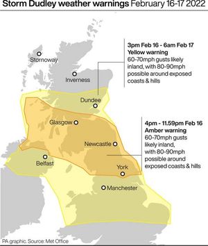
Strong winds of up to 90mph brought by Storm Dudley could pose a danger to life in parts of the UK on Wednesday, forecasters have warned.
The Met Office has issued an amber warning for “very strong and disruptive” winds which could cause widespread chaos, including a “good chance” of power cuts and disruption to transport services.
The warning says: “Injuries and danger to life is likely from large waves and beach material being thrown onto coastal roads, sea fronts and properties.”
The warning is in place from 4pm until midnight and covers a large belt across the middle of the UK, including regions north of Hull in the East Riding of Yorkshire and south of Perthshire in Scotland.
Forecasters have said residents in this region can also expect heavy showers throughout the afternoon and snow on high ground.
Met Office forecasters have said the conditions are caused by Storm Dudley which will move across the northern half of the nation from Wednesday night into Thursday morning, and Storm Eunice which follows.
Traffic Wales has said Dee Viaduct on the A5 and A483 will close on Thursday and Friday as a precautionary measure with high winds expected.
Southbound lane closure is expected from the A483 Junction 1 on Thursday ahead of a full closure on Friday from 6am-midnight, with a diversion route in place.