80 years of Shropshire's 'golf ball' landmarks on Titterstone Clee Hill
Anniversary detected – and it hasn't slipped under the radar.
Because this is the 80th anniversary year of one of Shropshire's more unusual landmarks, on one of the county's highest hills.
The radar station on the top of Titterstone Clee Hill will have been top secret when it was first erected in 1941 during some of the darkest days of the war.
And while that original station has long disappeared, the more modern radar on the hill today forms part of a national radar network, as well as playing a key role in providing weather information for the Met Office.
In the first chapter of the Clee Hill story the equipment was looked after by a small group of RAF radar operators and mechanics.
Windswept and remote, RAF Clee Hill may not have been a popular posting for its 40 to 50 RAF members, despite the breathtaking views. It was a residential unit and, until September 1956, they lived in huts at the top.
After that they lived in Ludlow and only went to the station during working hours.
With the hill covered by sheep, the airmen told of one of their number who foolishly went "baa" one evening and, like a Pied Piper, arrived on duty followed by a flock of 30 sheep.
A newspaper feature looking into their work in June 1957, when the commanding officer was one Flight Lieutenant Hole, said: "Life was not so pleasant when the men lived, as well as worked, on the hill. One or two still on the strength recall being isolated in snowdrifts, and talk of times when the temperature fell to minus 10 degrees."
Presumably the article at that time would measure it in Fahrenheit, so that minus 10 degrees translates as minus 23 degrees Celsius.
Another disadvantage was the expense of travelling to Ludlow. Senior Aircraftman John Taylor, one of those who had lived on the site, told our reporter that the cost of the bus fare at the time was 2s. 6d. return (about 13p today).
Bert Hobby, a civilian who had been a radar boffin in the unit for seven years, had however grown to love the hill and "will have many regrets when the station is closed in October."
So it closed in October 1957, then.
After the closure of the unit the BBC reportedly put a portable mast on the hill to relay signals from Sutton Coldfield. We say reportedly because we wonder if the reporter made the common mistake of confusing Titterstone Clee Hill with Shropshire's other Clee Hill, Brown Clee Hill (which is Shropshire's highest hill).
In any event, in the summer of 1961 the Ministry of Aviation was taking a look at Titterstone Clee with a view to setting up a new radar station there.
And so it was that in 1964 that the hill saw a revival of its radar station function, this time with the start of operations for a radar station owned by the Civil Aviation Authority. It was manned around the clock by at least two people and formed part of a national air traffic service providing advice and control to civil aircraft.
It could still be a tough and lonely posting, around 1,700ft up. For instance in January 1968 Roy Beachill of Ashford and Joe Hanlon of Ludlow found their Land Rover baulked by snowdrifts at Dhustone and, braving high winds, walked the last two miles through five foot drifts.
At least on arrival they had some home comforts. The station was centrally heated and had stocks of emergency food, snow shoes, and a hand-operated snowplough for cutting paths through the drifts.
Time on watch was normally 16 hours, although 24 hours was not uncommon.
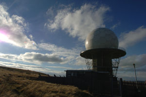
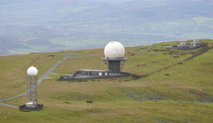
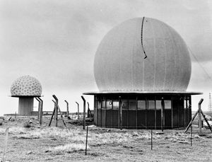
The radomes, as opposed to masts, seem to have appeared in the early 1970s. They were certainly there by 1977, because a gale in November 1977 destroyed one of the domes, although as it happened it was empty as the equipment within had been removed because the base was awaiting new equipment. A replacement 40ft radome appeared in 1978.
No doubt the technology has been updated more than once since those days.
Today the radomes, which famously look like large golf balls, are part of the National Air Traffic Services radar network monitoring civil and military aircraft in a 100-mile radius, and the Met Office weather radar network.