14 Shropshire flood warnings remain with river levels expected to peak again in coming days
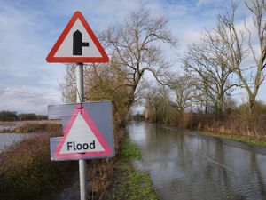
A total of 14 flood warnings remain in place in Shropshire this morning..
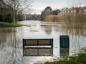
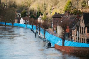
In Shrewsbury, temporary flood barriers are to remain in place at Frankwell until further notice, while defences were also installed at Coleham Head yesterday as experts and council leaders expect river levels to remain high over the weekend.
Shropshire Council said that peaks in the River Severn from rain that fell upstream in catchment areas on Wednesday and Thursday are still yet to pass through. Meanwhile a weather warning for rain, that was issued for western fringes of the county and the whole of Wales, expired at midday.
An update issued by the authority said: The River Severn in Shrewsbury is now falling slightly, but will remain high today. We are expecting a secondary peak tomorrow night into Monday following the rain last night. We will keep you updated as soon as we have more details about this.
"Bridgnorth is expected to peak at between 4.5m and 5.0m this evening or overnight."
Telford & Wrekin Council has warned that river levels in the Ironbridge area are expected to peak between 5.7m and 6.2m this afternoon.
In an update, the authority said: "The next peak is due on the afternoon of Monday 16 January afternoon, flooding of lower-level properties may occur along with some roads and footpaths."
The flood warnings in place around the county are at:
River Severn at Bridgnorth
River Severn at Coleham Head, Shrewsbury
River Severn at Fort Pendlestone and Severn Hall
River Severn at Frankwell, Shrewsbury
River Severn at Hampton Loade and Highley
River Severn at Ironbridge and Jackfield
River Severn at Pentre
River Severn at Quatford
River Severn at Shrawardine, Montford Bridge and Mytton
River Severn at Shrewsbury
River Severn at the Showground and The Quarry, Ironbridge
River Severn at the Wharfage, Ironbridge
River Vyrnwy at Maesbrook
River Vyrnwy at Melverley
There are also flood alerts at:
River Dee catchment in England from Whitchurch to Chester
River Severn in Shropshire
Severn Vyrnwy confluence
Tern and Perry catchments
Upper Teme
Natural Resources Wales also says flood alerts also remain in place at:
Lower Dee catchment
Upper Dee catchment
Upper Severn catchment
Vyrnwy catchment
Road closures in Shrewsbury
Coton Hill, Chester Street/Cross Street and Smithfield Road became the first roads shut on Friday to reopen on Saturday evening.
The road closures are:
Gravel Hill Lane
Sydney Avenue
Atcham to Cross Houses and Chiltern Farm Lane
Berwick Road
Old Coleham
Victoria Avenue
Coleham Head Lane – lane closure into town centre
Coleham Head – for EA demountable barrier
Longden Coleham out of town
Atcham to Berwick Wharf
Williams Way
Raven Meadows at the Roushill side Roushill
Cressage to Eaton Constantine
It's planned for Longden Coleham and Belle Vue Road to reopen Sunday morning once flood levels recede and the area cleaned. The flood barriers at Coleham Head will remain in place until Sunday afternoon before the authority looks at reopening Coleham Gyratory.
B4380 Shrewsbury to Atcham is open again but with temporary traffic lights due to water on the road.
Other closures included footpaths from Greyfriars Bridge to The Weir, The Pig trough to West Mid Showground and New Street to The Stew/Frankwell Riverside Car Park. Porthill footbridge, linking Porthill Road and The Quarry is also closed with water covering the bottom of the bridge in the town centre park.
Temporary bus terminals have been set up due to the closure of Shrewsbury bus station. Buses will arrive and depart from either New Park Road below Beacall’s Lane, coach bays and half the lower section of Abbey Foregate car park, Theatre Severn or, in the case of Oxon Park and Ride, Frankwell Island.
Anyone planning to visit Shrewsbury town centre is urged to use the park and ride instead of driving with three car parks - Frankwell Main, Frankwell Riverside and St Julian's Friar's - all closed until further notice. Raven Meadows multi-storey remains open for daytime parking, but Shropshire Council has warned "Raven Meadows will have two way flow for access to the multi-store and The Strand and exit".
Ironbridge
Telford & Wrekin Council has closed The Wharfage and Ferry Road - although cafés and shops along the Wharfage are set to remain open and can be reached on foot, along with other businesses and visitor attractions around the town. Builwas Road and Coalford are also closed, with the council saying that alternative access to areas of Jackfield can be accessed via Calcutts Road.
The Wharfage and Dale End car parks have now been shut too.
Sandbags have been delivered to residential areas known to be at risk and are Coalford, Ferry Road, Station car park, Ladywood and Wharfage car pak.
Bridgnorth
Further south, Shropshire Council has now closed some roads in Bridgnorth. They are:
Southwell Riverside
South Road & Boat Yard
Doctors Lane
Severn Terrace
Quayside
Riverside &Friars Street
The footpath
Riverside and Riverside West Elevated Resident car parks are now closed, as is the footpath from Bylet to Wellmeadow.
Ludlow
On Friday the 738/740 Ludlow to Knighton bus service operated by Minsterley Motors was unable to operate fully due to the flooding in the area.
The service was only able to operate between Ludlow and Leintwardine, with the section onwards towards Knighton cancelled.