Ice warning in place for West Midlands before Storm Goretti set to bring heavy snow
Ice warnings are in place across the West Midlands ahead of a storm which is set to bring heavy snow later in the week.
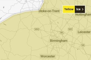
The Met Office has issued yellow ice warnings for most of the UK, including Northern Ireland, for Wednesday morning amid an Arctic air mass which has brought wintry showers across the country.
It includes Shropshire, Mid Wales and the West Midlands and is in force until 10am today.
Forecaster Marco Petagna said: “In the ice warnings, be careful of slippery surfaces and potential for injuries, so take care on footpaths.
“Icy patches could affect untreated roads, not all roads and pavements and cycle paths are treated so just be aware that away from major highways there could be icy and slippery conditions for a while tomorrow morning.”
The Met Office has advised those travelling on Wednesday morning to check road conditions, bus and train timetables and amend travel plans if necessary.
A yellow warning means some disruption is possible, such as travel delays, but many people can continue with their daily routine, according to the forecaster.
It comes before a yellow weather warning for snow for the West Midlands will be in place from 6pm on Thursday until midday Friday.
The severe wintry weather will be brought by the strong winds over northern France, named Storm Goretti by the country’s forecaster, Meteo France.
West Midlands weather forecast
Today:
Another cold day is expected, with icy stretches at first and the odd shower, possibly wintry. Gusty winds for a time too. Becoming dry with more in the way of sunshine, and winds easing during the afternoon. Maximum temperature 5 °C.
Tonight:
Remaining dry this evening with variable cloud. Turning cloudier overnight with spots of rain, sleet and drizzle arriving from the west. Chilly with a patchy frost, and winds easing. Minimum temperature -1 °C.
Thursday:
A cloudy start on Thursday with patchy rain and drizzle. Turning increasingly unsettled later, especially overnight, with heavy rain and snow, accompanied by strong winds leading to difficult driving conditions. Maximum temperature 5 °C.
Outlook for Friday to Sunday:
Rain and snow clearing eastwards then a largely dry end to Friday. Brighter and drier on Saturday with frost early and late. Further rain, snow and strong winds on Sunday.