Heavy rain predicted as UK braces for Storm Babet
Heavy rain and strong winds have been forecast as the country braces itself for Storm Babet.
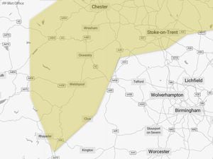
The Met Office has issued warnings as Storm Babet approaches, which is set to bring disruptive rain and strong winds to the UK in the coming days.
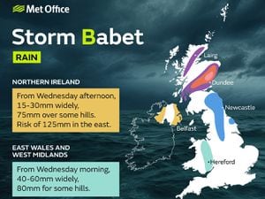
Whilst Scotland is set to see the worst of the bad weather, 40 to 60mm of rain is expected to fall across east Wales and the West Midlands from Wednesday morning, with 80mm expected for some hills.
For residents of Shropshire and the Welsh border, Babet is currently set to pass overhead at around 3pm on Wednesday.
Wednesday evening should see the heaviest of the rain, which is predicted to hang around until the early hours of Thursday.
On Monday, Environment Agency staff recorded the first "high flow" measurement of the autumn season. The agency recorded 108 cumecs (tonnes per second) of water flowing down the River Severn at Montford.
While levels were dropping and do remain within the 'normal' range, heavy rain falling onto already saturated ground does increase the chances of flooding.
Met Office deputy chief meteorologist Tony Wardle said: “Storm Babet will bring disruption for parts of the UK in the coming days, with heavy rain and strong winds likely for many.
“Heavy and persistent rain will fall onto already saturated ground bringing a risk of flooding. It is important to stay up to date with warnings from your local flood warning agency as well as the local authorities."
Residents can keep up to date with the latest flood risks in their areas at: check-for-flooding.service.gov.uk/find-location