Storm Babet: New threat looms over Shropshire's rivers
A named storm is set to bring heavy rains to the region where flood alerts remain in place after the weekend deluge.

The next deluge - named Storm Babet has been forecast to arrive from the Western Approaches on Tuesday and bring "impactful rain across parts of the UK" on Wednesday.
Met Office forecasters say Storm Babet will bring increasingly wet and windy weather that will spread more widely across the UK on Wednesday bringing heavy downpours to most parts through the day.
Scotland is set to bear the brunt of the weather beast with warnings of Biblical levels of rainfall up to 150-200 mm of rain in some areas of higher ground.
Steven Keates, the deputy chief Meteorologist, said: “Storm Babet will bring impactful rain to many parts of the UK, but especially parts of eastern Scotland, Northern Ireland and northern England later this week.
"Heavy and persistent rain will fall onto already saturated ground bringing a risk of flooding. It is important to stay up to date with warnings from your local flood warning agency as well as the local authorities."
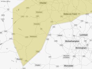
Flood alerts still in place across the Shropshire region include the River Severn, the River Dee from Whitchurch to Chester, the Severn Vyrnwy confluence and the Tern and Perry catchments.
Flood warnings for the Ledwyche Brook and River Rea and the Upper Teme have been removed in the last 24 hours.
Waters on the River Severn at Welsh Bridge in Shrewsbury are forecast to continue to fall into the start of Wednesday.