Change in weather as weekend thunderstorms on the horizon
The weather could be set to undergo a dramatic change after days of hot and humid weather across the region.
Following a week of sunny and hot weather, with temperatures regularly hitting 30°C and higher, the Met Office has issued a warning of thunderstorms hitting the region on Saturday afternoon.
A yellow warning is being issued by the Met Office, covering an area from Manchester down to the Cotswolds and across to central Wales and into Norfolk and Suffolk in the east, with Shropshire, the Black Country, Staffordshire and Wyre Forest all covered by the warning.
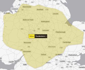
The office said the thunderstorms may happen between 2pm and 9pm and could lead to spray and sudden flooding, meaning difficult driving conditions and road closures, as well as the possibility of delays and cancellations to train and bus services.
A spokesman for the Met Office said: "There will be early mist or fog clearing through the morning, leaving another very warm and mostly dry day.
"However, the chance of a shower developing during the afternoon, perhaps heavy and thundery. Maximum temperature 31 °C."
West Midlands Roads have issued a warning on Twitter about the possibility of thunderstorms.
The message said: "The Met Office has issued a weather warning for thunderstorms which covers the West Midlands.
"The warning is valid for Saturday, September 9 between 2pm and 9pm
"Heavy rainfall may cause some localised flooding, which could disrupt travel."
To find out more and to check weather forecasts for the region, go to metoffice.gov.uk