Shropshire flooding: River Severn warnings still in place but most roads back open
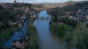
Flood warnings remain in place across Shropshire but key roads are open in Shrewsbury where the River Severn peaked this morning.
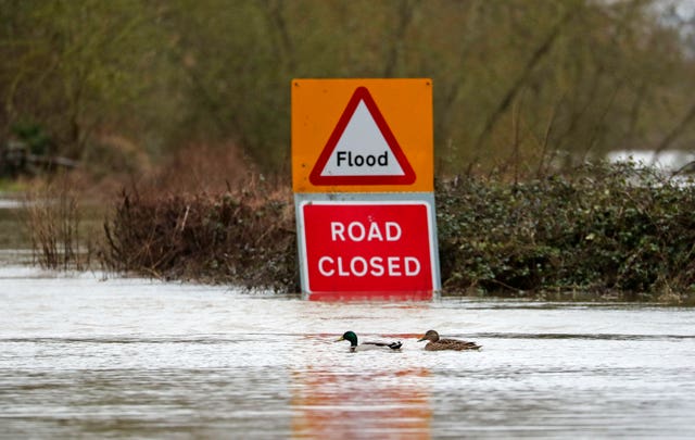
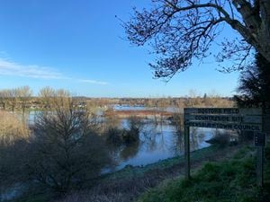
Many riverside areas are still under water across the county and there were 14 flood warnings in place for Shropshire this afternoon, including along the River Severn from Montford Bridge down to Bridgnorth and for the River Vyrnwy at Maesbrook and Melverley.
However the Severn is now receding in Shrewsbury after rising throughout Sunday and peaking at 4.24m at the Welsh Bridge in the early hours of Monday morning.
Scroll down for a full list of the latest road and car park closures
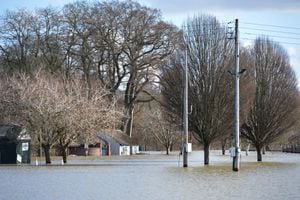
Frankwell and St Julian's Friars car parks remain covered in flood water and closed, as do several riverside roads and most of West Mid Showground, but roads such as Smithfield Avenue and Longden Coleham that flooded last week are clear of water and open for traffic.
The train and bus stations are operating as normal, as are the town's Pride Hill and Darwin shopping centres, while the park and ride service has been made free by Shropshire Council in a bid to boost trade.
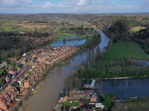
In Ironbridge, where the Wharfage flood barriers have been repaired after being pushed back and damaged by the water last week, the Severn was expected to peak at between 5.4m and 5.8m on Monday afternoon – about a metre down from last Wednesday's 6.79m. Flooding is affecting properties on Ferry Road.
And in Bridgnorth, where the riverside car parks are still closed, the Severn was expected to peak between 4.6m and 5.1m on Monday evening. Flooding is affecting properties on Severnside, Severn Terrace, Riverside and local caravan parks.
#backtobusiness - how to take part
Let us know when your business is back in action after the floods
Let us know how people can help
Tell us about customers and residents who have gone above and beyond to help
We'll share the best stories with our readers and help Shropshire get back on its feet
TWITTER - use the hashtag #backtobusiness to share your stories with us
FACEBOOK - Visit our Facebook Community Noticeboard to share your stories
Flood warnings were in place all along the River Severn on Monday afternoon, including at Quatford, Shrawardine, Montford Bridge and Mytton, the Showground and The Quarry, Shrewsbury, Quatford, and Hampton Loade and Highley.
Alerts – where flooding is possible but not expected – were also in place on the River Sow and River Penk, the Severn Vyrnwy confluence and The River Dee Catchment in England from Whitchurch to Chester.
David Throup, of the Environment Agency, said: "Almost the whole length of the River Severn in England is at flood warning level.
"Much of it will remain that way for several days."
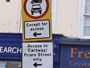
Road and car park closures
The following were closed on Monday afternoon.
Shrewsbury roads
Old Coleham
Gravel Hill Lane
Sydney Avenue
Atcham to Cross Houses
Chiltern Farm Lane
Victoria Avenue
Berwick Road
Roushill and Raven Meadows
Cressage to Eaton Constantine
Williams Way
Town Walls (due to a gas leak)
London Road (for BT cable work)
Shrewsbury car parks
Frankwell main and riverside
St Julian's Friars
The NCP car park on Wyle Cop is open with limited spaces due to flooding
Raven Meadows multi-storey, The Gap and the Premier Inn car park are all open but with no access from Roushill by the Salopian pub.
North Shropshire roads
Colliery Road, St Martins
Clarke’s Lane, St Martins
Burma Road, Park Hall, Whittington
South Shropshire roads
B4368 Clun to Newcastle (road slip)
Doctors Lane, Bridgnorth
Severnside South Bridgnorth
Telford roads
The Wharfage
Tontine hill/High Street in Ironbridge
Ferry Road
Lincoln Hill
Church Hill
Paradise
Clean-up continues
Shropshire Council’s assistant director of commercial services, Tim Smith, said the authority was on hand to help with the clean-up.
He said: “In Shrewsbury we’re really trying to focus on the clean-up now in the most affected areas – especially Coleham. The key thing for us is that the roads and pavements are free of debris and are safe for the public.
“We also want to ensure that the right health advice is going out to people. For instance, if people are removing sandbags, they need to be using gloves to do it safely, but if anyone needs help we can provide that.
“Shropshire Council is also supplying more skips for the people who need them.”
The authority is also busy ensuring affected businesses and homeowners are able to claim money off the government as part of the Flood Recovery Grant Scheme.
Some will be able to seek three months of relief from council tax and business rates as they start to salvage their properties.
There is also up to £500 available for homes and up to £2,500 for businesses hit by flooding. According to the authority, there is about 450 properties eligible in total.
“We’ve had a really good response to the Flood Recovery Grant Scheme,” Mr Smith said.
“Our customers service teams will be getting in touch with these people and checking who is eligible.”
Forecast
After a wet and windy weekend thanks to Storm Jorge, there was a sunny but icy start to Monday in Shropshire with the afternoon forecast to be cloudy but dry as residents and business owners continue to recover from the damage caused by two weeks of flooding.
A UK average of 202.1mm of rain fell last month, surpassing February 1990 when 193.4mm fell, the Met Office said.
WATCH Monday's weather forecast:
Thousands of homes and businesses were flooded nationally as areas were deluged by more than a month's worth of rainfall in just 24 hours, while some 127,000 properties were protected by flood defences this winter, authorities said.
Some 15 rivers in the Midlands, Yorkshire and Lancashire recorded their highest levels on record and the Environment Agency warned the country needs to brace itself for “more frequent periods of extreme weather like this” because of climate change.
The downpours, which started with Storm Ciara and continued with Storm Dennis and then Storm Jorge, contributed to record river levels which saw hundreds of emergency staff working on flood defences and pumps, clearing debris and repairing damaged defences across the country.
The Government has said it is investing £2.6 billion in flood defences by 2021.
More than 3,300 properties in England are thought to have been flooded as a result of the combined effects of storms Ciara and Dennis, the Department for Environment Food and Rural Affairs said.
Across the UK
A total of 82 flood warnings were still in place for England, Wales and Scotland this morning after the effects of Storm Jorge over the weekend.
Ice warnings were also in place for western areas from northern Wales to the top of Scotland, and the western half of Northern Ireland after the storm which helped the UK to its highest February rainfall on record.
The Environment Agency (EA) said 76 flood warnings were in place for England – mostly in the South West, along the Welsh border and in Yorkshire – with a further three such warnings in each of Wales and Scotland.
A total of 164 less serious flood alerts – advising of potential flooding – remained active for England, Wales and Scotland.
Although heavy downpours have eased, authorities have advised of possible traffic disruptions on Monday morning owing to the continuing flood situation.
Rail travellers using the West Coast main line have been warned to expect disruptions this week as repairs are made to a section of line near Warrington which was damaged in a landslip on the weekend.
The southbound line at Dutton Viaduct has been closed for the repairs and is expected to be shut for several days, Network Rail said in a statement.
For the first time since the flooding started, there were no reported evacuations in the worst-hit areas of East Yorkshire on Sunday.
Water levels are generally dropping or remaining stable in Snaith, Gowdall, East Cowick and West Cowick, but are expected to remain high for several days, East Riding of Yorkshire Council said.