UK 600-mile rainstorm weather: Thunder forecast for West Midlands city - When could it thunder?
Watch the Met Office’s 14-day weather outlook, as BBC Weather forecasts thundery showers for a West Midlands city.
BBC Weather is forecasting a West Midlands city to be hit by thundery showers.
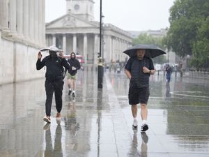
After the UK enjoyed warmer temperatures last week, cooler weather could be on the way, with a reported 600-mile rainstorm set to hit.
When could the UK 600-mile rainstorm hit?
National World reports that a UK 600-mile rainstorm looks to begin on August 27.
Southern Scotland and the East Midlands could be the hardest hit areas.
However, according to WXC Charts weather maps, there are some areas that may miss out on the wet weather.
These are Aberdeenshire, Somerset, Middlesex, Kent, Essex, Suffolk, Norfolk and Cambridgeshire.
When is it forecast to thunder in the West Midlands?
BBC Weather's forecast is currently showing ‘thundery showers and a gentle breeze’ for Stoke-on-Trent on September 1.
The Met Office’s UK long-range weather forecast says "low pressure in the Atlantic is expected to bring a change in weather to the UK"
For the period of August 24 to September 2, the Met Office’s UK long-range weather forecast says: "High pressure is likely to be the dominant feature at first, which would bring widely fine and dry weather for the Sunday of the Bank Holiday weekend.
"Whilst this is happening, low pressure in the Atlantic is expected to bring a change in weather to the UK, though the timing of any specific features is currently uncertain. From early to mid-week, high pressure is likely to become increasingly eroded from the west as areas of low pressure and frontal systems start to move in from the Atlantic, leading to more changeable conditions with spells of rain through the remainder of the week and the following weekend.
"Temperatures likely warm or very warm to start before quickly trending towards average."