West Midlands weather: Thundery showers could bring Saharan dust to air - are we experiencing a Spanish plume?
Watch the Met Office’s ‘Deep Dive’ forecast, looking at whether the country is experiencing a Spanish plume.
The UK is currently experiencing a period of warm weather.
The Met Office weather map shows temperatures could reach 23°C, 24°C, 25°C and 26°C in some parts of the country on June 11. On June 13, some places could even see temperatures of 27°C.
The Met Office has issued yellow thunderstorm warnings for Northern Ireland, Wales, South West England, parts of the West Midlands for June 12.
A yellow thunderstorm warning has also been issued for the East of England and London and South East England for the mid to late afternoon of June 13 to the early morning of June 14.
What is a Spanish plume?
According to the Met Office, a Spanish plume is “a weather setup which brings an increased risk of thunderstorms within an air mass which travels north from Iberia.”
What causes a Spanish plume?
A Spanish plume is caused by:
Very warm air pushing north from the Spanish plateau on a southerly airflow. This can happen at almost any time of year but during the summer months the extra warmth and moisture lead to increased energy available for storm development
Cooler air at height advancing from the west associated with upper troughs or cold fronts
Strong summer sunshine heating air at and near the surface across France and the UK
Are we experiencing a Spanish plume?
In the Met Office’s ‘Deep Dive’ forecast, meteorologist Alex Deakin said: “The air is coming from Spain, but it originates a little further south. It actually originates across northern Africa, so you could argue it's not a true Spanish plume but it is being affected by the mountains of central and northern Spain.
Saharan dust in atmosphere
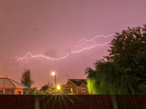
“They're [thundery showers] likely to have picked up some Saharan dust, so when it does rain don't be surprised if your car is a little dirtier in the mornings. It may well be that you wake up and there's little brown splodges all over your car from the overnight thunderstorms. When there's more dust particles in the atmosphere, it increases the likelihood of lightning.
“The one on Friday is more generated by this cold front coming northwards rather than thunderstorms coming in so again probably not a classic Spanish plume in that sense with these fronts coming northwards and generating their own rainfall rather than just that destabilisation of the hot air from the south. They're never quite the textbook classics but two examples of almost Spanish plumes coming through the rest of this week.”
West Midlands Met Office forecast
June 11
Remaining dry overnight with variable amounts of cloud. A chance of heavier rain arriving in the far southwest by dawn with a stronger breeze. A warm and humid night to come. Minimum temperature 12 °C.
June 12
Showery outbreaks of heavy, possibly thundery rain clearing northeastwards through the morning followed by sunshine and thunderstorms, these accompanied by gusty winds and hail. Feeling warm and humid. Maximum temperature 24 °C.
June 13 to June 15
Largely dry on Friday and feeling warm and humid. Heavy showers and thunderstorms arriving later. Sunshine and heavy, possibly thundery showers Saturday, these easing on Sunday. Feeling fresher but breezy.
Have you got a video you want to share with our readers? You can now send it to us online via YourWorld at https://www.yourworld.net/submit/ It's free to use and, once checked, your footage will appear on our website.