Shropshire weather: Thunderstorms and flash flooding hit parts of the county
Parts of Shropshire have been dealt one last batch of thunderstorms as heavy rain and lighting struck throughout the night - with heavy rain hitting parts of the county this morning.
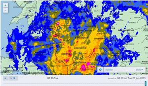
The Met Office said 29mm of rain was recorded in two hours this morning at Little Stanford, near Alberbury, between Shrewsbury and Welshpool.
Oswestry and surrounding areas straddling the Welsh border suffered the heaviest downpours on Monday evening and overnight, with rain continuing into this morning, where there were reports of flash flooding in Chirk.
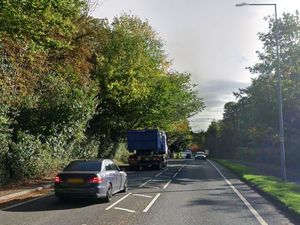
Water covered the whole of the road of the old A5 which runs through the village of Nesscliffe. Motorists were forced to halt in the middle of the carriageway before attempting to navigate the waters or turn back.
Other roads were forecast to flood, and AA Traffic News reported a number of weather warnings for heavy rain on the A483 near Morda, the B4396 through Knockin and the A5 from Shrewsbury to Gobowen.
The Met Office forecast "very intense" downpours with thunder and lightning expected mostly in parts of northern Shropshire, while issuing a yellow weather warning for northerly and westerly parts of the county.
Parts of Wem and Whitchurch were also affected by storms, as well as the outskirts of Shrewsbury.
Despite no flood alerts being implemented in Shropshire by the Environment Agency, standing water is understood to have built on roads in the north of the county causing delays.
Showers are likely to continue throughout today with warm, humid temperatures, before easing off tomorrow and setting in for hot temperatures of around 24C on Thursday.
The weather has meant Windmill Primary School in Brookside, Telford, has had to call off its sports day, due to be held today.
Watch today's Met Office weather forecast:
Elsewhere, fourteen people have been rescued by boat from a rugby club after it was hit by flooding.
Firefighters were alerted to the incident at Stirling County Rugby Club just before 8.45pm on Monday.
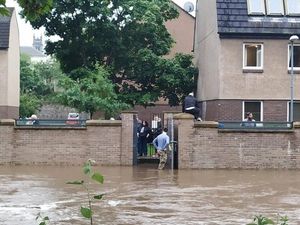
A spokeswoman said the Stirling fire station water rescue team sent a boat to rescue 14 members of the public from the club due to the flood waters.
Everybody was said to be “fit and well” following the rescue.
Meanwhile,thunderstorms powered up by a plume of warm continental air began to unload “hefty downpours” and flashes of lightning over south-east England this morning.
Hastings saw 13mm (0.5in) of rain fall in one hour, while 10mm (0.4in) was recorded at Sandhurst, the Met Office said.
Forecasters warned of “challenging” conditions for the morning commute, with a risk of localised flooding and surface water on roads posing a hazard to motorists.
Met Office meteorologist Simon Partridge said: “The storms have arrived along the south coast of England from the Isle of Wight to the Dove Strait with increasing amounts of thundery activity.
“Those storms are expected to clear by the time we get to 7am, leaving some light rain for an hour or so before it gets drier through the morning.
“The storms will continue north-eastwards over parts of East Anglia and the Humber before edging out over the North Sea.
“There could be some localised flooding, but certainly some surface water flooding which can cause problems to drive through as well as spray.
“So the early morning commute could be challenging, especially in areas north of London as that’s where the heaviest rain will be at that point.”
As well as problems on the roads, passengers using some southern routes have been advised to check for potential disruption to journeys.
National Rail Enquiries said passengers on Gatwick Express, Great Northern, Southern and Thameslink services could be affected.
The storms are being fed by an area of warm air that brought a muggy night for many – with temperatures only falling to 20C (68F) in some parts of the South East.
The mercury is expected to climb quickly after the lively weather moves through, with up to 27C (80F) expected in parts of the south on Tuesday afternoon.