Ice warning in place for Shropshire
An ice warning was in place for Shropshire this morning as temperatures dipped overnight.
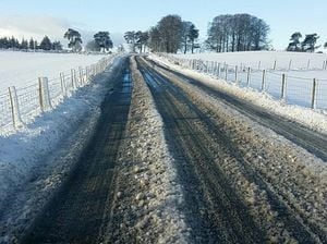
It comes after snow fell just over the county's border in south Powys yesterday, leading to traffic problems.
Snow was also reported to have settled on top of the hills in south Shropshire.
The Met Office issued a yellow weather warning for ice between 4pm yesterday and 11am this morning.
There were also flood alerts in place.
It followed a warning of rain and snow over Boxing Day night and into yesterday morning, although Shropshire missed the worst of the conditions which arrived elsewhere in the West Midlands and parts of Mid Wales.
Yesterday, warnings were put out on social media over the condition of some roads in Powys.
Radnorshire neighbourhood policing team in Powys tweeted: "Take care when driving between Knighton and Presteigne over Hare's Green roads are passable with care."
Powys County Council also expected the snow and ice to affect bin collections.
A post, tweeted yesterday from the council's account, said: "Due to the snowfall and ice in some parts of Powys there may be some areas that we are unable to reach with the refuse and recycling collections today.
"We are not expecting many properties to be affected and we will try to collect from those we miss as soon as we can."
Yesterday, nationwide thousands were left without power as wintry weather swept in over night on Tuesday, with Western Power Networks saying more than 14,000 properties had been cut off.
The Upper Teme, Ledwyche Brook and River Rea, River Arrow and River Worfe were also subject to alerts warning that flooding was possible.
The forecast is for today to be generally drier and a day with slightly less wind, although it will remain cold.
Temperatures for Shropshire were expected to reach highs of 4C ( 39.2F) and lows of -3C (26.6F) today.
Wet and windy weather is expected to return for the weekend, raising the risk of some flooding.
Elsewhere in the country yesterday, a lorry crash on the M1 closed all three southbound lanes and left traffic backed up in its wake, with a string of weather-related crashes scattered across the country.
The RAC said it saw a 15 to 20 per cent spike in call-outs compared with this time last year, including 12 relating to a pothole causing significant damage to vehicles on a section of the M25 around London.
There were similar stories of disruption, cancellations and delays at the country's travel terminals, with Stansted Airport twice temporarily closing its runway due to ice.
Some of the worst traffic was on the southbound carriageway of the M1 near Lutterworth in Leicestershire which was closed after an accident involving a lorry.
Highways England also reported "severe conditions" in both directions on the A14 near Kettering, with motorists asked to avoid the area while all available resources were deployed to help move vehicles, some of which had been stuck for several hours, and clear snow from the carriageway.
Another HGV jack-knifed in heavy snow on the M5 in Gloucestershire, as heavy snowfall overnight into Wednesday affected western parts of central England.