Lightning strikes over Shropshire as storms batter county
[gallery] Violent thunderstorms set light to a telegraph pole and brought roads to a standstill as the region took another battering from the weather.
Dramatic images emerged today of lightning strikes - as forecasters warned of possible wintry showers later this week.
Rivers levels were rising through Shropshire today following a weekend in which up to an inch of rain fell.
Flood alerts were issued by the Environment Agency for a number of rivers as the forecast warned of more heavy rain to come.
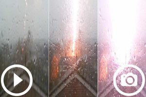
Chloe Tripp, 12, captured the moment a lightning bolt struck across the Telford skyline during the storms.
It appeared to strike a house in the Woodside area, although there were no reports of any damage caused to homes in the area.
Chloe Tripp's lightning video:
Chloe sent the pictures and videos to her father, Ian Tripp, who said: "I was amazed by the video, it caught the exact moment. Her pictures are good but the video is unbelievable. Chloe was amazed too."
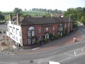
Fire crews were called to The Wheel Inn in Worfield, near Bridgnorth, after a telegraph pole was struck by lightning.
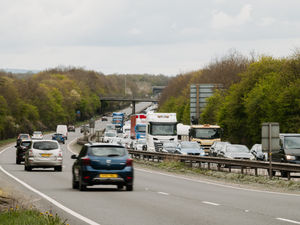
Traffic on major routes including the M54 came to a virtual standstill as motorists struggled through torrential rain and hailstones.
And lightning strikes across Shropshire were captured in photographs by several Shropshire Star readers.
One bolt appeared to strike a car that was travelling on the M6, close to its junction with the M54.
The moment was captured by Robin Hartley, 26, from Leegomery in Telford, who was travelling back home with his girlfriend, who was driving.
Photographer Ian Sheppard filmed this hail storm from his car in Wem.
He said: "We could see all the flashes before the rain came so I took my phone out ready to try to catch one.
"I took one as the next flash happened and when I checked the photo I couldn't believe it. We were both quite excited. We love storms."
Paul Bunch, the official photographer at Halfpenny Green Airport near Bridgnorth, captured a dramatic bolt of lightning in the background with a plane on the runway
Tim Brannon, from Westbeach Flight Academy, based at the airport, said: "It was all quite dramatic. It was forecast to a degree, but not to that degree.
"Paul was setting up to take some pictures when it rolled in. We had to bring all the flights down and he was in the right place to catch that picture."
As Saturday's storm passed over the county, the thunder was followed by hail, forcing many people to seek shelter.
Ellerdine Lakes Trout Fishery sent us this video of the storm hitting:
However, members of Bridgnorth Rugby Club's 1st XV braved the worst of the storm, playing through the lightning and hail to a 29-0 victory.
Club fixtures secretary Robin Glover said: "We continued playing during the thunder and lightning and the hail storm. There was some water on the pitch but both sides kept playing. The hail was bad, it was quite heavy, and the lightning was right overhead. "
Many county residents took to Twitter to share their weather stories.
Martin James, from Telford, said: "Have noticed in Telford, thunder & lightning, hail, gusty winds and rain. That about covers it. No plague of locusts!"
And S&V Handbury-Madin in Shrewsbury tweeted: "From blue skies and sunshine to dark skies and hail all in the space of half an hour. Never heard thunder this loud!"
Dave Throup, from the Environment Agency, said the weather front had shown up on radar as a "very intense squall line with some torrential rain appearing on radar behind the squall line."
Upload your pictures and videos to Star Witness using the box below or tweet @ShropshireStar
He added: "We had another 5-10mm rain in the lowlands to 20mm in the Severn headwaters on Sunday morning."
Flood alerts have been issued on some rivers in Shropshire. An alert was issued today by the Environment Agency for the Severn Vyrnwy confluence to the south of Oswestry. A peak river level was expected at Crew Green this morning as more heavy rain was expected.
Water levels on the Rivers Tern, Perry, Roden, Strine and Meese and their tributaries were expected to peak overnight, while upstream of Ludlow the Rivers Teme, Onny and Corve and their tributaries were expected to peak this morning.
This afternoon the B5398 in Whitchurch was closed between the A525 Nantwich Road and Bridgewater Street following flooding.
Meanwhile, the Rea and Cound Brooks and their tributaries are still rising, with levels expected to peak tomorrow.
Gritters last night took to the roads of Shropshire as temperatures started to drop.
Ice could become a problem later in the week as cold air comes in from the north, and there is a chance that some areas could see some snow.
A spokesman for the Met Office said: "It will colder across all areas with showers or longer spells of rain that may turn wintry in places, especially over hills.
"The weather will be unsettled and windy on Tuesday with showers or longer spells of rain which will be wintry at times, then becoming colder and drier with easing easterly winds from Wednesday."
Follow @EnvAgencyMids and #floodaware on Twitter for the latest flood outlook, and to sign up to receive free flood warnings.
Environment Agency Live Flood Warning map - updated every 15 minutes