More than 70 Shropshire roads set for 'surface dressing' - here's where
Shropshire Council has confirmed more than 70 stretches of road set for surface dressing in the coming months.
The authority says the work will play a key role in "improving the county’s roads and preventing potholes".
It said the work is due to begin from April 22, and will be carried out by Kier on behalf of the council.
The 72 sites identified are located across the county and include all types of road, from urban roads to major A- and B-roads.
The council said dates and details of work will be available on the One Network interactive roadworks website once road space permits have been granted.
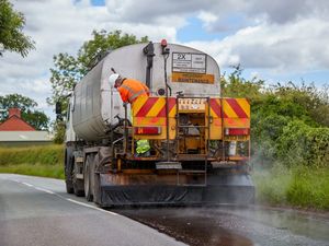
It said surface dressing is a "quick, efficient and cost-effective way of preventing potholes, maintaining skid-resistance and waterproofing road surfaces".
It forms a major part of the council’s annual road maintenance programme and is being carried out alongside other preventative and reactive maintenance work.
The county's roads have deteriorated in recent weeks, with huge numbers of potholes opening up after cold and wet weather since the turn of the year.

David Vasmer, Shropshire Council’s cabinet member for highways and environment, said: “As well as improving and protecting our roads, this important programme of work plays a crucial role in helping to prevent potholes and other defects forming in the future. Pothole treatment is very much about prevention as well as cure and this is one important way that we can aim to prevent potholes forming next winter.”
Surface dressing involves applying and rolling aggregate ‘chippings’ onto a bitumen binder.
The council said: "It will seal the surface, improve surface texture and prolong the life of the road by many years.
"To ensure work is delivered in safe and practicable manner the sites will unfortunately require a temporary road closure for the works to be carried out safely.
"Where road closures are not necessary, other forms of temporary traffic management will be in place, including temporary signals where appropriate.
"For the majority of A- and B-roads centre line studs/cats’ eyes also need to be removed and replaced under a temporary closure. It’s envisaged that stud/cats’ eye removal will take place overnight between 8pm and 6am, followed by dressing, sweeping and reapplying road markings during daytime hours.
"The replacement of studs and road markings on some sites may necessarily need to take place up to 10 days later.
"In reality, most of the road closures will only be required for a few hours for the dressing operation, and are unlikely to be of more than one day in duration.
"The programme of work may alter due to wet weather or other unforeseen events.
"In order to keep affected residents and road users informed of when and how long closures will be in place advance information signs will be positioned on each site in the weeks preceding proposed commencement of works."
The full list of roads due to be surface dressed in 2026
Condover Green to Cantlop crossroads
Chatbrook junction with A49 to Church junction, Stapleton
Unnamed road from A49 through Stapleton
Stapleton to Moat Farm
Pulverbatch to Newhouse Lane
JunctionJunction at Stitt Farm to Brow Farm junction, Ratlinghope
Four Turnings junction to Home Farm junction, Asterton
Plowden to A49, Craven Arms
Woodhill Road and Bridgnorth Road, Highley
Boundary Gate Farm to Upper House Junction, Abdon
B4368 Aston on Clun to Broome
Newcastle to County Boundary at Anchor
County boundary with Penyllan to county boundary Churchstoke
Pontesford Hill to Grove Lane, Pontesford
A488, Pontesbury to Hanwood
Porthill Road, Shrewsbury
Harmer Hill to Alderton
Marton to Baschurch
Duglands junction to Severn View, Edgerley, Kinnerley
Glanyrafon to Cefn Blodwel, Treflach
Unnamed road from A483 to Morda
Pentre-shannel South to junction west of Belmont, Trefonen, Oswestry
Pentre Gwyn Lane, Llansilin
Cydygan Lane, Llansilin
Junction North of Rhydycroesau to junction South of Morda River Bridge, Llawnt
Bradley Fields, Oswestry
High Fawr Avenue, Oswestry
Bryn Rise, Oswestry
Llanforda Mead, Oswestry
Breidden Close, Oswestry
White Minster, Oswestry
High Lea Close, Oswestry
Hampton Fields, Oswestry
Whittington to Ellesmere
Ellesmere Road, St Martins
Burlton to B5063, Loppington
Goblins Lane End to Browns Brook junction Abbey Green, Wem
Ash Road, Whitchurch
Church Lane to County Boundary, Broughall
Brades Road, Prees
Junction Hermitage Lane Farm to A49, Hine Heath
Booley Road, Stanton Upon Hine Heath
Kenstone junction to junction Hermitage Lane Farm, Hine Heath
Kenstone junction to A53, Hine Heath
Kenstone Road Paradise to Hopton Road, Hine Heath
Whitehouse junction to Hill Cottage junction, Marchamley Wood
Wood Lane, Marchamley
Wollerton Crossroads to Cotton Farm, Hodnet
Stoke-on-Tern to Ollerton
Hinstock to Ellerton
Holly Coppice crossroads to Haughton
Upton Magna to Holly Coppice crossroads, Haughton
Uffington to Upton Magna
Tern Lodge to Norton crossroads
Norton crossroads to Uppington
Uppington to Bluebell, Uppington
Victoria Road, Shifnal
Broadway Close, Shifnal
Newport Road, Albrighton
Badger Lane End to Staffordshire county boundary, Bridgnorth
Buildwas Road, Buildwas
Much Wenlock to Morville
Severn Valley Railway Knowle Sands to Eardington
Chelmarsh to Severn Valley Railway Bridge, Chelmarsh
The Square to Riddings Lane, Stottesdon
Netherton Lane to Church Lane, Highley
Froggy Lane junction to Harpswood Bridge, Middleton Priors
Tern Lodge to Grange Cottages, Atcham
Carpenters Lane (end of) to North Cottages junction, Stanton Lacy
Clee Hill to Knowlegate, Clee Hill
Clee Hill Road from Burford to Ellendene
Ledwyche to A4112, Burford