Environment Agency objects to giant Shrewsbury houses plan over lack of flood information
The Environment Agency has objected to plans for more than 400 new homes in a Shropshire town over a lack of flooding information.
The organisation has written to Shropshire Council to lodge a formal objection to plans from Taylor Wimey and Persimmon Homes.
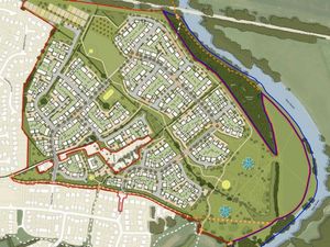
The firms want to build up to 430 homes on land at Weir Hill, which is off Preston Street to the east of Shrewsbury.
The companies have already built more than 600 homes at Weir Hill, as part of phases one and two of the development.

The latest application represents the third phase of the scheme.
But in a letter responding to the application the Environment Agency has said it wants more information about flood assessments for the site before it is prepared to back the scheme.
It said: "We object to the proposed development due to an inadequate assessment of flood risk."
It said that most of the application site is based on land at low risk of flooding from the River Severn, but also includes some areas at medium and high risk of flooding.
The letter states: "We have reviewed the Flood Risk Assessment and at this stage, we object to the proposed development due to an inadequate assessment of flood risk.
"The following comments are provided to explain our position.
"The application site is bordered by the River Severn to the east. Based upon our indicative flood map for planning much of the application site falls within flood zone 1, land defined by planning practice guidance as having a low risk of fluvial flooding.
"The map does however indicate areas of flood zone 2 and 3 (medium/ high risk of fluvial flooding) within the eastern section of the site."
"There is also an ordinary watercourse present within the centre of the site, which would appear to discharge to the River Severn. Flood risk associated with this watercourse is unmodelled on our flood map as the catchment falls below 3km², this does not mean there is no flood risk."
Outlining what it needs to remove the objection the EA letter states: "We recommend that a more accurate and detailed assessment of flood risk for the ordinary watercourse is submitted, as outlined above, to provide certainty on the developable area to inform site layout (reserved matter), finished floor levels and any other mitigation.
"An updated Flood Risk Assessment should also provide further evidence and explanation of fluvial flood risk from the River Severn."