Shrewsbury flood warning warning removed - but Shropshire remains on alert
Shropshire remains on flood alert today as river levels stay high - and a popular festival venue has been hit yet again.

An official flood warning in Shrewsbury, the only one in the entire country, was removed shortly after 11am - while the River Severn was expected to peak in Ironbridge and Bridgnorth this morning. Official warnings mean floods are expected and immediate action is required.
The situation is looking far less bleak than in previous years, when the reading at the Welsh Bridge gauge has topped 5m and caused water to spill into the road and into town centre shops and pubs, sometimes leaving people stranded. Cars have still been able to get in and out of Shrewsbury town centre and all car parks bar Frankwell remain open.

The government's flood checker said: "Welsh Bridge peaked at 3.4m on Friday evening. Further heavy rainfall is forecast over the next 48 hours. We are closely monitoring the situation. Our incident response staff are checking defences. Please plan driving routes to avoid low lying roads near rivers, which may be flooded."

The offices of the West Mid Showground in Gravel Hill Lane, Shrewsbury, have been flooded, prompting tomorrow's car boot sale to be cancelled.
A spokesman for the showground said: "Car boot cancelled this Sunday due to flooding, again. We hope to see you all next week the 19th for our last car boot of the year."
Shrewsbury Parkrun was also cancelled this week in the Quarry due to high river levels.
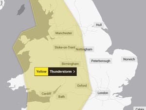
There are now four flood alerts in the county, meaning flooding in these areas is "possible". There is a county-wide alert for the River Severn, as well as ones for the River Dee catchment in England from Whitchurch to Chester, the Severn Vyrnwy confluence and Tern and Perry catchments. An alert for the Upper Teme has been removed.

Further down the river, workers were preparing the Ironbridge barriers yesterday ahead of this morning, when the river is expected to peak. The flood checker said: "Buildwas predicted peak 4.1m to 4.6m Saturday morning, Bridgnorth 3.1m to 3.6m Saturday afternoon."
The county-wide alert for the Severn said: "River levels have risen at the Buildwas river gauge as a result of Storm Barra. Flooding continues. We expect flooding to affect low lying land and roads adjacent to the river from Shrewsbury to Upper Arley. Locations that may be affected are Coalbrookdale, Ironbridge and Bridgnorth. Floodplain at Leighton starts to fill. Crew Green peaked on Thursday, Montford peaked Friday morning,"

The Met Office's forecast for today said: "Dry at first but becoming wet with rain and drizzle. Some brightness first thing in the east, otherwise cloudy but dry to begin the day. Rain arriving in the west during the morning, spreading east through the afternoon. Becoming milder. Maximum temperature 10 °C.
"Tonight: remaining generally cloudy this evening and overnight with rain and drizzle at times, tending to become lighter by the morning. Very mild and remaining frost free. Minimum temperature 8 °C.
"Sunday: another largely cloudy day with the odd pocket of drizzly rain during the morning. Some brightness is possible, particularly during the afternoon. Becoming breezier by the evening but feeling mild. Maximum temperature 13C.
"Outlook for Monday to Wednesday: cloudy with rain, occasionally heavy, on Monday. Drier and brighter on Tuesday before further rain moves south through Wednesday. Breezy at times but staying on the mild side throughout."
No reports of flood incidents have appeared on the fire service log.