Flood warnings issued across Shropshire as river levels rise after heavy rain - towpath also closed in Shrewsbury
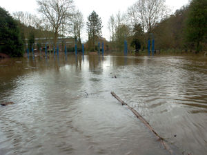
Flood warnings and alerts have been issued across Shropshire after heavy rain caused river levels to rise sharply overnight.
The Environment Agency (EA) confirmed this morning (September 21) that river levels remain high but steady across key gauges in the county, with some areas already experiencing flooding.
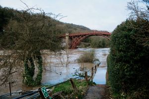
Warnings and alerts have been issued in areas including Maesbrook, Melverley, Llanymynech, and the wider Severn-Vyrnwy confluence area, following heavy rainfall throughout yesterday (September 20).
A flood alert also remains in place for the River Dee catchment from Whitchurch to Chester.
In response to rising river levels, Shropshire Council also announced that the riverside towpath in Shrewsbury between Greyfriars Bridge and the weir has been closed until further notice.

A flood warning - meaning flooding is expected and immediate action is required - has been issued for the River Vyrnwy at Maesbrook and Melverley.
At around 8am today, the River Vyrnwy at Llanymynech was measured at 4.49 metres - above the property flooding threshold of 4.30m.
The EA stated: "River levels are high but steady at the Llanymynech river gauge as a result of heavy rainfall. Flooding continues.
"We expect flooding to affect properties and roads in and around Melverley including Melverley to Melverley Green and Ponthen to Melverley roads.
"No further rainfall is forecast in the next 24 hours. We expect river levels to remain high until Monday (September 22). We are closely monitoring the situation. Please avoid contact with flood water."
A flood alert - indicating possible flooding - also remains in place for the Severn-Vyrnwy confluence. Low-lying land and roads between Llawnt and Shrawardine near Shrewsbury, including areas around Llanymynech, Maesbrook, and Melverley, are likely to be affected, according to the EA.
Further upstream, the River Severn at Crew Green near Shrewsbury was recorded at 4.05 metres at 8.30am - below the 6.20m flooding threshold.
Meanwhile, the level at Cae Howel near Oswestry was measured at 1.58 metres, also below flood thresholds.
In northern parts of the county, a flood alert has also been issued for the River Dee catchment, covering areas from Whitchurch to Chester. The EA said river levels could reach flood thresholds overnight.
Residents in all affected areas have been advised to monitor updates and take precautions.
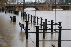
As a precaution, Shropshire Council has also closed the Shrewsbury town centre towpath between Greyfriars Bridge and the weir due to rising water levels on the Severn.
The closure came into effect at 9pm on Saturday evening and will remain in place until further notice.
A council spokesperson said: "Due to rising river levels in Shrewsbury we will be closing the towpath between Greyfriars Bridge and the weir."
Further information can be found here.