River levels dropping but alerts and warnings remain as Storm Babet's effects still felt in Shropshire
Five flood warnings and four alerts remain in place but river levels are dropping as the effects of Storm Babet are still felt in Shropshire.
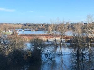
River Severn warnings are still in place in Bridgnorth, Frankwell in Shrewsbury, Hampton Loade and Highley, Ironbridge and Jackfield and Quatford.
However, a warning at the Quarry and the West Mid Showground in Shrewsbury, which is regularly faced with damage and destruction from floods, was removed on Tuesday evening.
Levels at the Welsh Bridge gauge in Shrewsbury are falling, and were down to 2.65m after a peak of 4.14m on Sunday evening. The level in Bridgnorth has dropped down to 3.91m after a peak of 4.57m on Monday afternoon. The Buildwas gauge also shows the river level falling. As of this morning at 8.15am it was at 4.55m, after peaking at 5.61m on Monday afternoon.
Latest flood alerts (updates every 10 minutes):
An update issued by the Government's flood checker on the Quarry and West Mid Showground just before 6pm on Tuesday said: "River levels have now fallen below the flood risk threshold. The flood warning for the area has now been removed. However, a Flood Alert remains in force for the wider area, so flooding may still affect roads and low lying land. Further rainfall is forecast over the next couple of days.
"We continue to monitor the situation. Our incident response staff are checking the condition of defences.
"Please avoid using low lying footpaths near local watercourses."
The most recent update for Bridgnorth on the flood checker said: "Flooding is expected in this area. This means properties are at risk of flooding.
"Please take action to protect yourself and your property and monitor local weather and river conditions. Avoid contact with, walking or driving through flood water. Consider activating any property flood protection products you may have.
"Environment Agency Flood Warning Officers set the river or tidal levels that have triggered this message. During industrial action this message has been automatically issued based on rising river or tidal levels."
The most recent Frankwell update, issued five days ago, urged people to avoid using low lying footpaths or entering areas prone to flooding. Start acting on your flood plan if you have one.
It said: "As the Frankwell barriers have been deployed and are fully operational, we are currently not expecting protected properties in this area to be impacted."
Flood alerts - which are less serious than warnings - are still in place for the entire River Severn in Shropshire as well as the River Dee catchment from Whitchurch to Chester, the Severn Vyrnwy confluence and the Tern and Perry catchments.
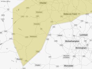
The Met Office has issued a yellow warning for fog, and warned commuters to expect slower journeys and delays on buses and trains. It affects most of Shropshire and is expected to remain in place until 11am
The forecaster said today will be "a dry but cloudy to start the day for most".
It added: "Low cloud clears through the morning to bring sunny spells. Temperatures a little lower that previous days but feeling pleasant in the sunshine in light winds. Maximum temperature 12 °C."
It predicts tonight there will be a band of light rain and low cloud moves in from the southwest, perhaps turning heavy at times overnight. Rain clearing to the northeast and feeling cooler than last night. Minimum temperature 7 °C."
Tomorrow is expected to see a bright start for most although cloudier in the northeast.
"Showers developing into the afternoon, but sunny spells in between. Winds remain light throughout and feeling rather cool. Maximum temperature 14 °C," said the Met Office,
Friday to Sunday is expected to remain unsettled into the weekend with showers or longer spells of rain. Showers could turn heavy at times, but some sunny spells in between. Temperatures around average.