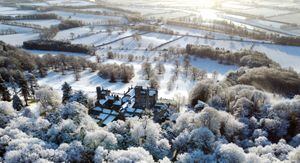
Shropshire weather: Snow forecast as temperatures drop again across UK
Snow could fall in Shropshire as the mild New Year conditions are replaced by unsettled weather and sub-zero temperatures, forecasters have said.

Light snow showers are possible in higher parts of the county on Tuesday evening and Wednesday morning, according to the Met Office.
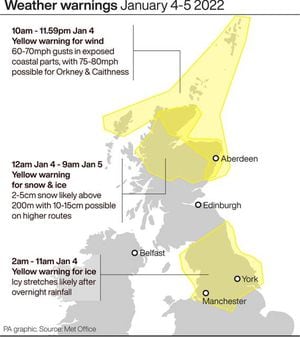
However the chance of any significant amount of snow building up in the region this week appears slim, with severe weather warnings only in place for the Highlands of Scotland and north England.
After an unseasonally warm start to the year, temperatures in Shropshire and Mid Wales are expected to drop to just above freezing on Tuesday evening before heading below zero on Wednesday night.
Snow is possible from late Tuesday afternoon until dawn on Wednesday and is most likely on higher ground in north and west Shropshire, according to the Met Office.
Oswestry and Welshpool have the highest likelihood of snow, but wintry showers could also hit Telford, Whitchurch, Bishop's Castle and Church Stretton.
No snow is forecast for Bridgnorth or Shrewsbury.
A band of rain is moving from south-west England, south-east Wales and across to the Wash, gradually moving east, with wintry conditions on higher ground.
On Wednesday a ridge of high pressure will bring dry conditions for most of the UK, along with showers on the North Sea coast from time to time.
Temperatures will fall to below freezing overnight into Thursday, giving the UK the first widespread frost of the winter, Mr Miles said.
Looking towards the weekend, temperatures are expected to rise slightly, but the picture remains unsettled with wintry showers expected for some.
Strong winds, coupled with the snow, have led to treacherous travelling conditions in northern Scotland.
The Met Office warned of 60mph-70mph gusts, possibly stronger for a time, for Orkney and Caithness.
Strong winds on Tuesday also affected a number of ferry services operating in Scotland.
Met Office spokesman Richard Miles said: “It’s going to be colder than we have been used to over the last couple of days and Christmas.
“We are going into a period when temperatures will be dropping quite a bit.”
Snow warnings have been issued for the Highlands of Scotland, with snow also having fallen on the Pennines in northern England.
Blustery, wintry showers are expected to continue, with more snow expected on higher ground in England and Wales.
A weather warning for snow in built-up areas of Scotland remains in place for Friday.