Shropshire flood talks planned after council says it received ‘inconsistent’ river data
Shropshire Council says it will hold discussions with the Environment Agency after it said "inconsistent data" made planning for potential flooding "extremely difficult".
The local authority said it would be asking the Environment Agency, which provides river gauge information, to review the system to make sure people are warned effectively.
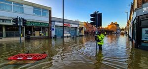
It comes after some residents in Coleham, Shrewsbury, which was hit by major flooding on Thursday night, said they had been left unsure about the scale of the situation due to differing reports on gauge levels.
See also:
A spokesman for Shropshire Council said: "The responsibility for providing the Flood Warning Service and gauge information on the River Severn sits with the Environment Agency.
"Shropshire Council rely on the same flood warning and river gauge information to plan our operation response to flooding, and the inconsistent nature of the gauge data made planning for – and responding to – this event extremely difficult.
"Shropshire Council will be requesting that the Environment Agency undertake a review of the current system and the we will work with them to ensure warnings go out to communities more effectively in the future."
Decisions
Mark Davies who owns Darwin’s Townhouse, which saw major flooding causing thousands of pounds of damage for the second time in 11 months, said: “It went forward, back, then it was almost by the moment. We were basing our decisions on what we were given – that is all you have to go by. They need to get their stuff together.”
In response the Environment Agency has said it had been warning about the possibility of flooding several days before it happened. The organisation also said that people should make sure they check flood warnings, and not just the Environment Agency’s readings on river levels.
An Environment Agency spokesman said: “River models are inherently complicated, linking millions of data lines together that respond dynamically with the weather conditions.
“There are times when these completed models produce forecasts that don’t represent what we would expect to see.
“Thankfully our experts are trained to identify these computer model anomalies, and alongside their local area knowledge produce the advice and information in the flood messages which represents what we expect to see. As we included real, rather than forecast information, into the models they have responded to the changing information.
“The ground was already saturated at the beginning of last week and we then saw several days of sustained and intense rainfall. This means we were always expecting high levels and a quick response and is why we began taking action and communicating about the risk several days before the peaks happened.
“The river level forecasts are only one part of the Environment Agency’s warning and informing service and should always be viewed alongside the flood warning.”