Bygone Shropshire snaps get first public airing
Dozens of stunning images taken from the air, which capture Shropshire's bygone years, have been made public for the first time.
Dozens of stunning images taken from the air, which capture Shropshire's bygone years, have been made public for the first time.
Aerial images of Shrewsbury, Church Stretton and Ludlow taken during the 1920s and 30s feature among the major new collection of pictures that have gone online on the new Britain from Above website.
The pictures show how much of the county looked during the inter-war period and help to show how development has changed the face of Shropshire over the years.
See more pictures in our gallery to your right
Among the highlights is a picture of the English Bridge in Shrewsbury taken 1927. The image shows major reconstruction work being carried out on the 18th century bridge to make it suitable for motor cars.
The three-year project, masterminded by borough surveyor Arthur Ward, saw the bridge widened while retaining much of its original stone.
If you look carefully, it is possible to make out a temporary wooden bridge underneath the English Bridge which was used while construction was going on.
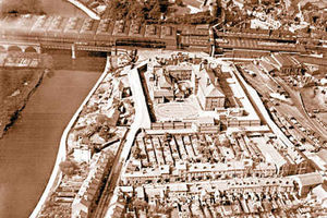
Another picture from 1927 reveals a glimpse of HM Prison Shrewsbury in Castlefields from above. In the background, just behind the prison, it is possible to see the former roof of Shrewsbury Railway Station which was torn down during the 1960s due to safety fears.
To the right of the prison stands Shrewsbury's Buttermarket, which recently reopened as a nightclub.
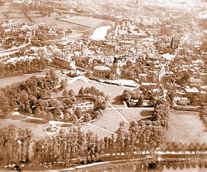
Shrewsbury Abbey dominates another snap taken in 1927. To the left of the church it is possible to see Abbey Foregate's former Old Pott's railway station.
This station was the terminus of the Shropshire and Montgomeryshire Railway in Shrewsbury until it was closed in 1960.
Shrewsbury's Quarry Park is the focus of another image, also taken in 1927.
A line of tall lime trees, running alongside the River Severn in the park can be seen in the foreground. These were cut down after the Second World War after fears they were becoming unsafe.
In the background, behind the Quarry, it is possible to make out the tower of the town's old Market Hall and even further back, its former Cattle Market – now the site of the Raven Meadows bus station.
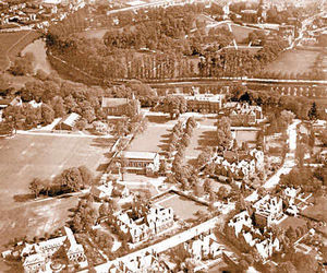
An aerial view of Shrewsbury School's main building as it looked in 1927 has also be captured. The 18th century building was originally built as a foundlings hospital. It was taken over by Shrewsbury School in 1882.
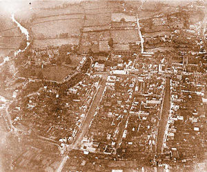
An aerial shot of Ludlow is also included in the collection. The picture shows Broad Street, and St Laurence's Church as they looked in 1926. Ludlow Castle can be seen in the top left hand corner, and the River Teme flows nearby.
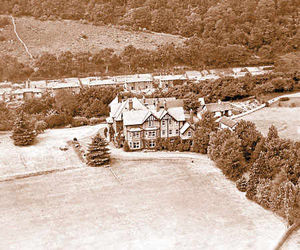
And another image taken in 1933 shows Brockhurst School in Church Stretton. The school was founded in Shropshire in 1884 before moving to its present site near Newbury in 1945.
Historian David Trumper, from Shrewsbury, said he was astonished by the quality of the aerial pictures. He said: "They are absolutely brilliant and show many interesting buildings – many of which were torn down in the 1960s."
The photographs are among more than 15,000 rare and fragile aerial photos of the West Midlands dating from 1919 to 1953 from the Aerofilms
Collection that have been made freely accessible online to the public for the first time.