A49 from Shrewsbury to Ludlow: The road to hell and back during Onibury closure
A red estate car is doing a three-point turn 200, maybe 250 yards up the road. It is a deep metallic red, possibly a Nissan. I'm not close enough to read the number plate, but probably not that far off.
It seems incredible to think that this car is the best part of a three-hour drive away. At least by the official route, anyway.
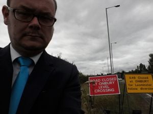
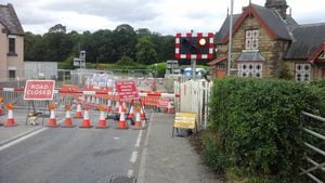
We're at Onibury level crossing, peaceful rural idyll just a few minutes drive from Ludlow. At least it is for me. If the driver of the red estate car wants to visit Shropshire's gourmet capital, he could be in for a long journey.
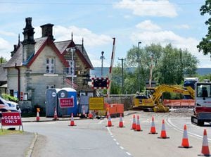
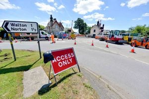
This week, the tiny village in south Shropshire has found itself well and truly on the map, literally. A road closure to allow for improvement work at the level-crossing has left drivers fuming as they have been forced to take a detour of up to 60 miles along the A49 from Shrewsbury to Ludlow. Buildings just a few yards away are suddenly out of reach. You can see the other side of the divide, but you can't get to it. It's what it must have felt like when the Berlin Wall went up, although to be fair, you can still walk over the level crossing, and there are no sentry guards taking pot shots at those trying to cross the boundary.
Just as I am surveying the scene, a truck driver delivering a piece of heavy plant equipment rolls up to ask for directions.
"I'm not from round here do you know how you get over there?" he asks. He cannot believe his ears when he hears what is going on.
"You're joking," he exclaims, as his jaw drops. "The sat-nav says I'm three minutes away," he adds, his mind still trying to process the information.
Now is probably not the time to tell him it has taken me two-and-a-half hours – admittedly with a few short stops along the way – to get from Shrewsbury.
My journey began just after 11am, at the services on the Dobbies roundabout near Bayston Hill in Shrewsbury. It is not the most auspicious of beginnings, when I inadvertently find myself in the lane for the drive-through coffee outlet. If I can't navigate my way around the service station, it doesn't bode well for the mother of all diversions.
Setting off at 11.09, I record the mileage on the car at 32,618. Ordinarily, a journey to Ludlow should be 29 miles and take 42 minutes, but something tells me I am not going to make it by midday.
Things start simply enough, a large sign very clearly marked "diversion" points the way off the island down the A5112 Hereford Road, although I am slightly confused by the two black square symbols which also adorn some of the signs. Another sign – and some more cryptic symbols – a few yards down the road appears to confirm I am on the right track, but then there is another notice saying "diversion end", little over a mile from the starting point. It seems there might be more than one diversion in Shrewsbury today. However, I also notice small black circles on yellow squares which have appeared on the main road signs, and decide to plough on with the route for a little while longer.
By the time I get to the shopping parade in Whitchurch Road, though, doubts are already beginning to creep in, and I pull over for a quick pit-stop. The instructions from Highways England say I should be taking the A458 to Bridgnorth, yet I am on the A5112 heading north towards Battlefield. Something tells me things have gone awry already.
As the circles give way to diamonds, I am faced with a dilemma – keep following the symbols, which appear to be directing me back to where I started, or follow the road sign for A458 Bridgnorth. Having already wasted 20 minutes without leaving Shrewsbury, I decide to forget the geometry and go with my gut instinct, and to my relief the diversion signs reappear near Condover.
The next stretch of the journey is plain sailing, and after 50 minutes and 21 miles, it’s time to pull in at the lay-by just before the village of Harley, where Glyn Horler is standing outside his snack van.
“We’ve had one or two people talking about the diversion, but we haven’t seen any real increase in traffic,” says Glyn, who owns the G & C Snacks business. It appears at least one trucker is actually quite pleased with the diversion, saying it is actually quicker than the route he normally takes. Every cloud has a silver lining and all that.
Maybe it’s the beautiful scenery that helps make people seem at ease. Heading towards Much Wenlock there are some rather wonderful views of the Shropshire Hills, and all seems well with the world. Some other drivers seem to be getting a little impatient, though. Heading down the hill towards Much Wenlock, I am rather aggressively overtaken, first by a white van, then by a black car. The black car then begins tailgating the white van, before then overtaking the van in quite a wild fashion. Slow down and enjoy the journey, lads.
Heading towards Bridgnorth, the wonderful Morville Hall is on the right. The prospect of stopping off for a couple of hours' sunshine around the grounds is tempting to say the least, but instead it is off to Morville Lunchbox, a mobile snack bar kept by Mandy Pengelle.
Mandy says the diversion has been the big subject of conversation among many of her customers who have called in for a bite to eat.
“It’s been a little bit busier today, I have had people come who I don’t normally see,” she says.
“A lot of people have been saying the diversion is a long way. You always get one or two who will moan.”
It is now 68 minutes since the start of the journey, and 29 miles have been travelled. Should be about halfway then.
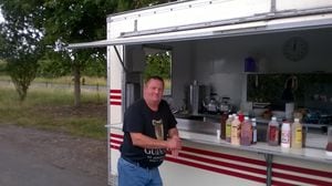
No time to stop at Bridgnorth Castle, either, as the route skirts past Low Town, over the new bridge across the Severn and past the caravan park and aluminium works. Hampton Loade, Quatt and Shatterford all pass by in a bit of a haze as rapid progress is made towards Kidderminster, where I stop for a chat with Nicky Griffiths, who runs a Nicky's Snack Shack just of the A442 Bridgnorth Road, about a mile before you get to Franche.
Nicky is full of the joys of summer, as she breaks off from her work for a brief chat.
"I have been doing it for about four years, I love it, being out in the countryside," she says. The increase in trade resulting from the diversion means she is out of crusty bread, but she still has plenty of Black Country pork scratchings, and what more can you ask for?
Nicky says she has spoken to a lot of unhappy truck drivers, some of who were unsure about the route of the diversion, or whether it was suitable for heavy lorries.
"Everybody has been talking about it today," she says. "A lot of them seem to be unhappy about it. One said he had to drive an extra 50 miles where he did not want to go because of it."
Heading through the congested, built-up Franche Road, I have a few nagging doubts about whether I have also ventured off the route again, but a quick glance in the rear-view mirror confirms that there are diversion signs for the reverse leg of the route.
A right turn at the splendidly named Dolittle & Dalley estate agent takes us towards Bewdley, although the diversion doesn't take us through the town whose name means The Beautiful Place – perhaps just as well, you wouldn't want HGVs clogging up the town's historic Load Street.
Swift progress is made through the Worcestershire Countryside, briefly drifting in and out of Herefordshire from time to time.
Heading towards Tenbury Wells, I spot something I really have to take a picture of – a scarecrow, dressed up as The Incredible Hulk, outside a garden supplies shop. I'm sure there's some good reason for it.
As I head back to the car, my curiosity appears to have aroused the attention of two ladies sitting in the window of the nearby Talbot Inn, one of who gives a cheery wave. Nervously, I repay the compliment.
Turning right at the junction, about half a mile or so along the road, my attention is drawn to Spiderman, suspended in the air from a giant web. There seems to be theme developing here. Perhaps rubbing salt into the wounds of the long-suffering hauliers and commuters, a beer tent has gone up outside the Rose & Crown pub. Hmm. Why would you want to go to a beer festival when you could be stuck on a 60-mile diversion?
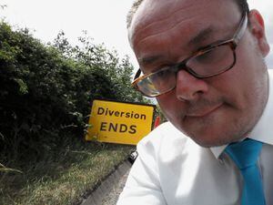
Continuing through Little Hereford, I notice that the geometric road signs have now changed to triangles – what exactly do all these symbols mean? Still, I'm not complaining. At 1.37pm, two hours and 28 minutes after leaving Shrewsbury, I see the sign I have been longing to see for a long time: Diversion ends.
The end of the route is just before Woofferton, on the outskirts of Ludlow, about five miles south of the town itself. The mileometer now reads 32,720, so I have driven 82 miles, on a trip that would normally be 30 miles, and take 44 minutes.
Over at The Salwey Arms in Woofferton, owner Matt Jenneson says he has been inundated with confused drivers coming in asking about the route.
"We get at least half a dozen in every day," he says. "They are usually asking for directions, or if there is a way around it."
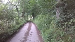
And indeed there is, but it is not surprising that the highways authorities are not particularly keen on promoting the alternative route I found with a little help from the sat-nav. Heading north, turn left before you get to the crossing, then right, and then following the twisty, single-track lane through the hills until you get to Park Lane at the end. Just about wide enough for a car, it is possible to get to the other side of the great divide in about 15 minutes, although it is not hard to imagine the chaos that would ensue if people tried it in any great numbers. An alternative route is to go north-west through Back Lane from Ludlow Golf Club, towards the Apple Tree pub.
But the myriad of short-cuts has caused a bit of consternation in neighbouring Craven Arms.
Andrew Griffiths, aged 63, of Market Street, says: "The trouble is that Onibury crossing has been shut many times over the years and the lorry drivers know the back roads and are ignoring the official diversion roads which take longer. People are simply ignoring the yellow signs and following their satellite navigation systems.
"There are a lot of HGVs coming into Craven Arms. They are heading to Corvedale then down to the racecourse at Ludlow and back onto the A49. We have no end of articulated lorries. They seem to be from a number of companies based in south Wales."
The one thing probably everyone will agree on is that the crossing's reopening on Monday can't come soon enough.
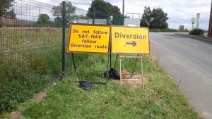
"Do not follow sat-nav, follow diversion route," say the signs, at least they do minus the punctuation. But when the diversion adds at least an hour to your journey time, it is not hard to see why people will try to find their way through.