Peak forecasts updated as bulge of water heads down the Severn in Shropshire
Environment experts have issued updated figures on when they expect the River Severn to peak as a bulge of rainwater makes its way down the waterways.
In an update posted at 8:34am on Monday the Environment Agency says river levels are continuing to rise at the Bridgnorth, Buildwas, Crew Green, Montford and Welsh Bridge river gauges as a result of heavy rainfall.
The predicted peaks are at Montford 5.2m to 5.6m on Monday afternoon, Welsh Bridge 2.7m to 3m on Tuesday afternoon.
Frankwell phase one barriers have been deployed in Shrewsbury and the predicted peaks are at or over the top of the normal range.
Other peaks are predicted for Buildwas, 4.0m to 4.3m, and Bridgnorth, 3.2m to 3.6m, on Tuesday evening.
Further upstream the gauge at Crew Green has been forecast to reach 5.6m to 5.8m overnight on Tuesday into Wednesday morning.
There are several flood alerts still in force in Shropshire, mid and north Wales following recent rainfall.
The Environment Agency say it expects flooding of roads and farmland.
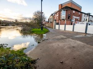
"We expect flooding to affect low lying land and roads adjacent to the river from Shrewsbury to Upper Arley," it said.
"Locations that may be affected are Coalbrookdale, Ironbridge and Bridgnorth and access to properties along Riverside in Bridgnorth."
Further rainfall is forecast over the next few days and river watchers are monitoring the situation.
The EA also asks the public to avoid using low-lying footpaths near local watercourses and plan driving routes to avoid low-lying roads near rivers, which may be flooded.
It said it currently had no plans to erect flood barriers in Ironbridge but further down the Severn, the agency confirmed it was working to erect barriers against the River Severn, on Severn Side in Bewdley.
A flood alert was issued for the river in Bewdley, which experts expect to flood, affecting low-lying lands in the area.
The alert, on the.Gov website, said: "River levels have risen at the Bewdley river gauge as a result of recent heavy rainfall. We expect flooding to affect low-lying land and roads adjacent to the river from Highley to Tewkesbury.
"Locations affected are Stourport, Holt Fleet, Worcester, Kempsey, Severn Stoke and Upton upon Severn."
Residents have also been urged to install property-level protection if required.
Demountable flood defences were recently completed on the Severnside South section of the river, bringing the defences up to the required level.
The latest flood warning comes as traffic restrictions in the town centre prepare to be lifted for the Christmas and New Year period.
As part of the lifting of the traffic restrictions, Stourport Road will be reopened to allow regular traffic through the holiday period.
The construction works are part of a £6.2 million scheme to install flood defence barriers in the Beales Corner area which has suffered from repeated River Severn breaches in recent years.
The new Beales Corner Flood Risk Management Scheme will feature a combination of removable flood barriers and permanent raised walls with glass panels.
As a result of the work Stourport Road, which connects to the B4190 Kidderminster Road, was closed in both directions between Kidderminster Road and Westbourne Street.