High winds set for midday as Storm Debi heads across the Shropshire region leaving flood warnings in its wake
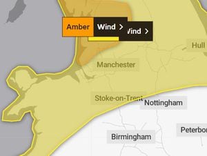
A yellow weather warning for high winds is in place across the north of Shropshire and mid Wales as Storm Debi crosses the UK.
In Oswestry, the Met Office says winds could gust up to 50mph from about midday and stay strong for much of the remainder of the day.
Weather experts say that winds at that strength could lead to flying debris some damage to buildings, such as tiles blown from roofs.
Other parts of the county could also see strong winds even though they are not covered by an official warning. In Shrewsbury this morning there were some strong gusts starting to blow at 8am.
A band of heavy rain crossed the county and mid Wales in the early hours. And in Mid Wales there is a flood alert issued by Natural Resources Wales, covering the River Vyrnwy, River Tanat and River Cain and their tributaries.
Natural Resources Wales says flooding of low-lying land and roads is expected.
Roads close to Meifod Bridge, the B4393 near Llansantffraid Bridge and the B4398 at New Bridge Llanymynech could also be affected by the rising levels.
In the same area but across the border a flood alert is in place for the Severn Vyrnwy confluence, where river levels are forecast to rise at the Llanymynech river gauge as a result of heavy rainfall.
Flooding of roads and farmland is expected to begin this morning (Monday).
The Environment Agency says: "We expect flooding to affect low lying land and roads adjacent to the river from the Welsh border at Llawnt to Shrawardine near Shrewsbury.
"Other locations that may be affected include Llanymynech, Maesbrook and Melverley."
The river is expected to peak at Llanymynech between 4.0 to 4.5m on Monday evening.
The Severn at Cae Howel could peak between 4.4m to 4.9m over night Monday as the water moves downstream in the river system. That could take it over the top of the normal range with further heavy rainfall forecast.
Elsewhere across Shropshire the EA says the flood risk for the next five days is very low.
However there are five flood alerts in place across the county and wider region including at the River Dee catchment in England from Whitchurch to Chester; the River Stour and Smestow Brook in the Black Country and South Staffordshire; the Severn Vyrnwy confluence, the Tern and Perry catchments and the Upper Teme.