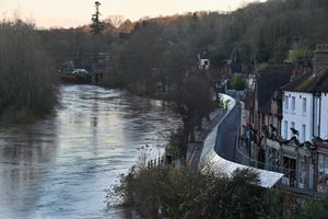
Latest river levels in Shropshire: Warnings in place as flooding of properties and businesses expected
After last week's snow and the storm over the weekend, some residents are now being warned the rising river levels are posing a threat to their homes and businesses.
The Environment Agency (EA) says it expects flooding to affect properties and roads in and around Melverley, at the showground and Gravel Hill Lane in Shrewsbury, Ferry Road in Ironbridge, in the Hampton Loade and Highley area and Quatford Caravan Park.
On Sunday, Shropshire Council began closing the Frankwell Riverside and main car parks and on Monday, flood barriers were being installed along the Wharfage in Ironbridge.
Across Shropshire, five flood warnings and six flood alerts were in place as of Tuesday morning.
The warnings, given when flooding is expected, cover the River Vyrnwy at Melverley, River Severn at the Showground and The Quarry in Shrewsbury, River Severn at Ironbridge and Jackfield, River Severn at Quatford and River Severn at Hampton Loade and Highley.
As of Tuesday morning, the Severn at Welshbridge appears to have passed its peak and was measuring 3.69m and falling, just short of a metre above the top of the 'normal' range. It peaked at 3.74m in the early hours of Tuesday morning.
Here, flooding of property is possible above 2.9m, with the highest ever level recorded at the river gauge at 5.25m in November 2000.

Downriver in Ironbridge, the river was expected to peak on Tuesday afternoon between 5m and 5.4m.
As of Tuesday morning, the Severn had reached 4.67m at Buildwas - 1.2m above the top of the 'normal range'. The EA says that property flooding is possible when the river reaches around 4.8m and was warning that properties on Ferry Road were expected to flood.
Properties in and around Hampton Loade and Highley were also being warned of flooding, with the river levels in Bridgnorth expected to reach 4.2m to 4.4m on Tuesday evening.
As of Tuesday morning, the Severn in Bridgnorth was measuring 3.75m, its highest-ever peak was also in November 2000, at 5.26m.
The flood alerts, where flooding is possible, cover Severn Vyrnwy confluence, Tern and Perry catchments, the rest of the River Severn in Shropshire, River Worfe, River Arrow and River Lugg North of Leominster.
All flood alerts and more information about river levels can be found on the Environment Agency website at: check-for-flooding.service.gov.uk


