Shrewsbury flood barriers going up as heavy rain causes chaos for commuters in Shropshire and Mid Wales
Flood barriers were going up in Shrewsbury today after heavy rain brought chaos for commuters in Shropshire and Mid Wales.
With more heavy rain forecast tonight in Shropshire and Wales, the Environment Agency was this afternoon putting low-level flood barriers up in Frankwell, alongside the River Severn in Shrewsbury, to manage the risk of local flooding early tomorrow morning.
The barriers were due to go up from 5pm, with the Severn expected to peak in Shrewsbury on Thursday afternoon. A decision on whether barriers go up in Ironbridge too will depend on tonight's rainfall.
David Throup, of the Environment Agency, said that with a lot of water already in the catchment and more rain forecast, the flood risk along the River Severn will remain raised for several days. Surface water flooding was also likely to be an issue overnight, he added.
Meanwhile, a tree came down on three cars in Bridgnorth and rail travellers were urged to avoid services between Chester and Shrewsbury by Transport for Wales due to flooding on the line.
Flood warnings - meaning flooding is expected - immediate action required, were in place across Shropshire for:
River Vyrnwy at Maesbrook
River Vyrnwy at Melverley
Flood alerts - meaning flooding is possible - be prepared, were in place for:
Rea Brook and Cound Brook
River Severn in Shropshire
River Sow and River Penk
Severn Vyrnwy Confluence
Tern and Perry Catchments
The River Dee Catchment in England from Whitchurch to Chester
Upper Teme
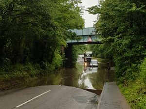
Newport Road under the railway bridge in Albrighton has been closed, with Albrighton Fire Station telling drivers to look for alternative routes, while water was over footpaths alongside the River Severn in Shrewsbury.
In Condover, Councillor Dan Morris tweeted pictures of flooding at the junction of Station Road and Grange Lane, and issue which he said had been going on for four years.
River safety campaigner Kirsty Walsh, tweeted: "The River Severn is very high today, please take care on areas where flooding is possible! You can become in danger very quickly! Check @WestMerciaSAR westmerciasar.org.uk/homeanddry/free-water-safety-online-course on how to keep safe."
Yellow weather warnings for rain remain in place for both today and tomorrow and forecasters predict parts of the UK could be hit by more than four inches of rain this week.
Residents are being told to avoid low-lying footpaths near local watercourses and plan driving routes to avoid low-lying roads near rivers which may be flooded.
Environment Agency regional manager Dave Throup has said that while a band of rain that has been hanging around since Monday will be clearing, more rain will make its way into our area from the south east this evening.
Heavy rain has also caused a lot of flooding in Westbury, near Shrewsbury, with a large pool of water blocking the road.
Fire crews were present in Welshpool town centre last night to try to pump away some of the water in the worst affected areas.
Crews from Welshpool and Llanfair Caereinion pumped flood water out of the Town Hall basement and nearby properties yesterday. They remained throughout the night. The market had to close due to fumes from the pumps.
And Rea Brook in Shrewsbury looked close to bursting its banks yesterday afternoon.
It is expected to be cloudy in Shropshire today and there will be some rain, which may become persistent at times. There will be a moderate to fresh north-easterly breeze, meaning it will be cool for the time of year, with a maximum temperature of 13C.
Rain will continue on and off heading into the weekend but the heaviest downpours are expected today.
Watch the Met Office forecast:
Today and tomorrow some parts of the UK could be struck by two to three inches of rain. Met Office meteorologist Alex Burkill described the figures as the “worst-case scenarios” but added that people need “to be aware that we’re in for some treacherous weather”.
Temperatures are likely to recover a little by the weekend, when brighter spells are also expected amid the showers. But there is no return to the wall-to-wall sunshine enjoyed last year, when the West Midlands was already in the grip of a heatwave.