Fresh weather warnings issued as heavy rain brings roads and rail disruption
Warnings will be in place until Sunday.
Fresh warnings of rain have been issued following heavy downpours which have led to road closures and affected rail travel in some parts of the country.
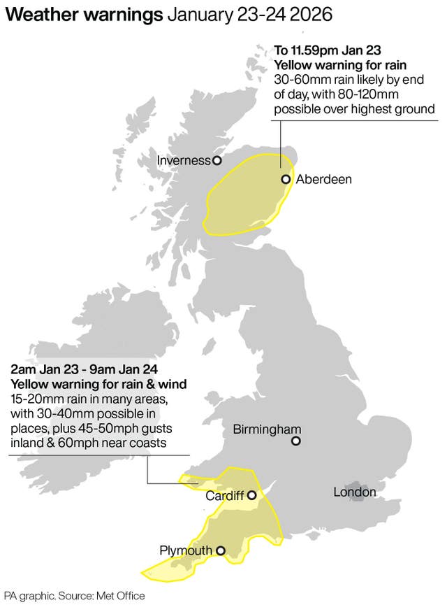
A Met Office yellow alert for rain in Perthshire, the Stirling area and some of north-east Scotland is in force until midnight and a further warning extending into Sunday has now been issued for part of that area.
Perth and Kinross Council said many roads in the region were closed due to flooding as of 6am on Friday, including the A94 between A93 Meikleour crossroads and A923 Bendochy crossroads, and the Queen’s Bridge in Perth.
On the railways, ScotRail said speed restrictions will be in place on the Inverness to Edinburgh/Glasgow/Aberdeen, Glasgow to Dumfries, Stranraer to Ayr/Kilmarnock and Glasgow to Mallaig/Oban lines.
The Scottish Environment Protection Agency has issued 22 flood warnings and seven flood alerts.
The Met Office yellow warning covers Angus, Dundee, northern Fife, Aberdeen, Aberdeenshire, parts of the Highlands, Moray, Perth and Kinross, and Stirling on Friday.
It warns of a “small chance of fast-flowing or deep floodwater causing danger to life”.
Forecasters said: “Rainfall accumulations of 30-60mm are likely fairly widely inland, with as much as 80-120mm possible over the highest ground exposed to the brisk south-easterly winds.
“Given the nature of the ground following recent rain and snow thaw, this may lead to some flooding in places.
“Rainfall totals will be smaller in coastal areas but strong onshore winds and large waves at times will be additional hazards.”
A yellow warning of rain in Angus, Perth and Kinross, Aberdeen and Aberdeenshire will be in force from midnight on Friday until 9am on Sunday.
Forecasters predict that rain will affect parts of eastern Scotland already affected by recent heavy rainfall, leading to further flooding and disruption to travel.
Many areas are likely to see a further 20-30mm of rain, and a few places could see 50mm, while above 400-500 metres a lot of this will fall as snow, forecasters said.
South of the border, a yellow warning of rain and wind in south-west England and southern Wales is in force until 9am on Saturday.
Forecasters said Storm Ingrid will bring spells of heavy rain and strong winds across parts of south-west England and South Wales during Friday before easing on Saturday morning.
Gusts of 45-50mph are expected widely inland and could reach up to 60mph near coasts, with winds peaking during Friday evening before gradually easing overnight and into Saturday morning.
The heavy rain brought travel disruption in Scotland on Thursday, with many roads affected by flooding.
Three people in Aberdeenshire had to be rescued from their stranded vehicles by firefighters.
Two people were rescued from a minibus on the B977 near Kintore at around 8.30am on Thursday while one person was brought to safety from a car in a separate incident at around the same time near Banchory.
The Scottish Government Resilience Room met on Thursday to discuss the weather situation.
Justice Secretary Angela Constance, who chaired the meeting, said: “I would urge people to pay attention to flood alerts, weather forecasts and to consider travel updates in their area.”