More evacuations in flood-hit communities as water levels keep rising
Shropshire, Worcestershire and East Yorkshire were the worst affected and more rain is on the way.
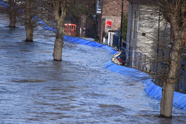
There is no let-up in sight for flood-hit communities in Shropshire and Worcestershire after heavy rain overnight caused the River Severn to breach emergency defences.
More wet weather is forecast in some of the worst-affected areas, with parts of Wales and the North West of England predicted to see another 0.8in to 1.6in (2cm to 4cm) of rain, according to the Met Office.
Railway lines into Shrewsbury were closed due to the rising water levels close to the viaduct.
Network Rail said: “The exceptionally high-water levels in the Severn and the closure of these lives serve to highlight the extreme weather we’ve experienced across the network over the last few weeks.
“The current situation in Shrewsbury is very much a once-in-a-generation event.”
It said engineers would be undertaking an underwater inspection of the viaduct’s structure on Wednesday morning before lines can reopen.
Residents in the Worcestershire town of Bewdley were forced to evacuate after the river spilled over barriers at Beales Corner.
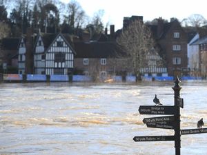
In the at-risk town of Ironbridge in Shropshire, the force of the river forced flood defences backwards, although they managed to hold.
Speaking at Ironbridge on Wednesday morning, Marc Lidderth, EA environment manager, said water levels had dropped by about 0.3in (1cm).
But he added: “The severe flood warning that we have issued here at Ironbridge is still in force, which means there is a significant risk to life, so we need people to remain vigilant and to listen to the advice that’s coming from the emergency services.”
He said that although the barriers had moved, they were still holding water and the over-topping the EA had feared had not happened.
The agency is keeping a close eye on the barriers on the Severn, Mr Lidderth said. He added that drones may be used later today to assess the defences.
Roads around the Ironbridge Gorge have also been closed to stop people driving in floodwater, Telford and Wrekin Council said.
The level of the River Severn reached more than 22ft (6.79m) in the Shropshire village of Buildwas at around 8.30am on Wednesday – up from a level of 16ft (4.19m) on Sunday.
On Wednesday morning there were two severe flood warnings – meaning there is a risk to life – on the River Severn.
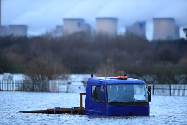
There were a further 102 flood warnings and 146 flood alerts in place stretching from the Lake District down to the south coast, with heavy concentrations in the North East and South West.
Many towns the length of the River Severn were also at risk.
In East Yorkshire, flood warnings remain in place in the Snaith area, with the Environment Agency saying the washlands at Gowdall Ings are continuing to fill and are over-topping, as designed, into Snaith Ings, with flooding affecting properties nearby.
Tim Marshall, a landlord who owns a flooded commercial property in Snaith, criticised the lack of warning and help he received ahead of the flood.
He said: “We got a warning in the morning (on Tuesday) from the Environment Agency that flooding was imminent and the ladies who run the two salons on the property, they spent the day getting as much equipment out as they could and, at approximately 12pm, they more or less said it is going to flood and, within half an hour it had happened, so that’s as much warning as we got.”
He added: “I rang the local council, as I was asked to do, yesterday morning and asked for some sandbags and things and got no response whatsoever.
“It’s not as if East Yorkshire’s that flooded that they couldn’t have got some sandbags out to us. Whether or not they’d have had an effect, I’m not sure, but at least we could have made that effort.”
Mr Marshall said he is covered by insurance and wants to get the property repaired quickly so the businesses can reopen.
He said: “From my point of view, it’s a brick building and, although I’m sad about it, I’m certainly not devastated. I’m upset to death for the girls and the homeowners.
“Unfortunately, one of the girls, her home has also flooded so she’s not only lost her home, she’s lost her business as well in this situation, which is terrible.”
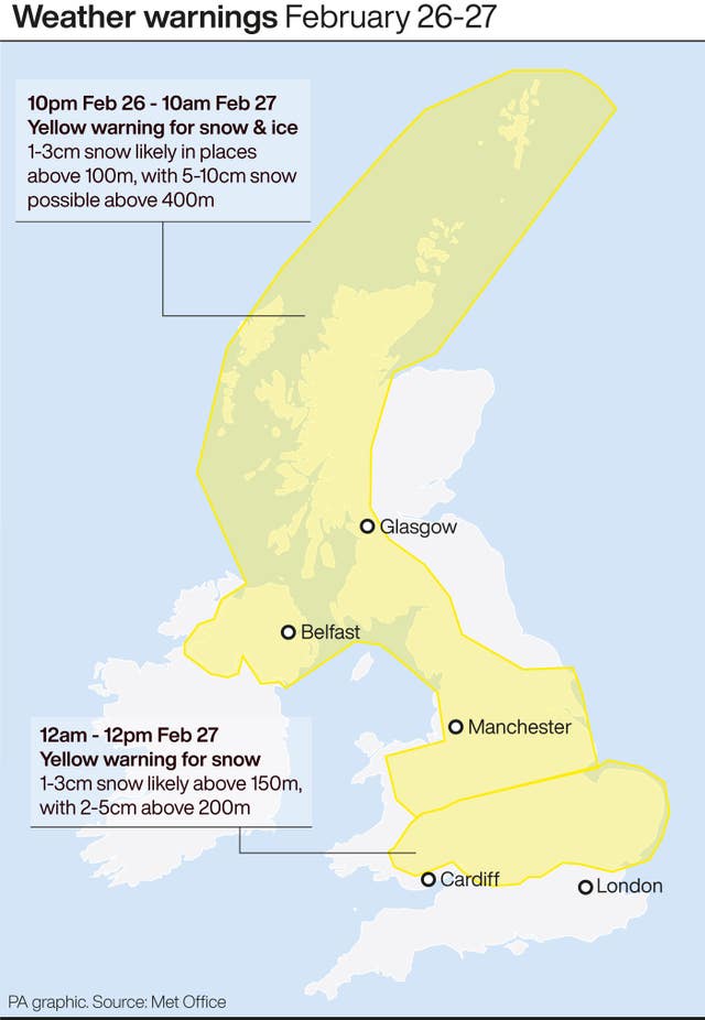
Elsewhere, there is a yellow warning for snow and ice stretching the length of western Scotland down to Loughborough in the Midlands due come into force at 10pm on Wednesday.
It will expire at 10am on Thursday and is likely to bring wintry showers and icy roads, causing some travel disruption and risk of injury.
Oli Claydon, a spokesman for the Met Office, said western parts of the UK would see a pattern of sunshine and showers over Wednesday and Thursday.
He said the volume of rain would ordinarily “be nothing to be overly concerned about”, but added any further rain could have an impact on flooded communities.
“In some of those regions through that period of rainfall, particularly into the Severn catchment, the total won’t necessarily be a huge amount but in any of those places that are seeing flooding, any further rain is not welcome,” he said.
Mr Claydon said that most of the UK would be dry by Thursday evening, before more heavy rain moves in from the west on Friday.
“In terms of impact, the main thing we are keeping an eye on now is Friday,” he said. “That is another area of concern – there could be yellow rain warnings on Friday in terms of the accumulations that could be expected from that rainfall.”
He said south-west England, southern parts of Wales and north-west England were expected to see the most rain on Friday and into the weekend.