What the constant rain in Shropshire and Wales means for the River Severn in the county
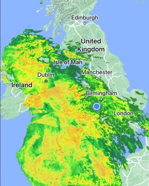
Torrential rain soaked Shropshire and mid Wales overnight, with weather experts saying that more flooding is inevitable.
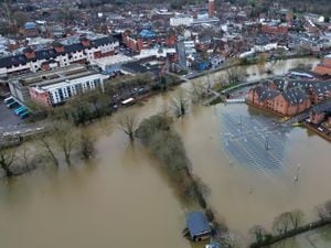
With a 28-hour weather warning for rain in place for the whole county until 9pm on Tuesday, a host of flood warnings and alerts cover the River Severn and its tributaries.
The Met Office said some areas could see 50 mm/two inches of rain in the warning period which began at 5pm on Monday.
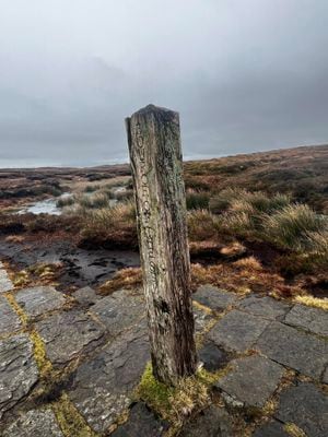
The longest river in the UK, the Severn starts in the heart of the mountains of mid Wales.
Photographs taken on New Years Day by David Jones on a walk to the source of the Severn show just how full the source, often just a trickle, is.

Clare Dinnis from the Environment Agency explained that the River Severn was experiencing multiple peaks rather than one travelling downstream as the onslaught of weather fronts hit Wales and the Midlands.
"Multiple peaks mean we’ve got warnings out along its length, as well as on the Wye," she said.
"The rivers are coping well with a lot of rain but levels are high and the ground is saturated. So take care and stay floodaware."
The result of the multiple peaks can be seen in the flood alerts.
For instance at Llanymynech the Severn peaked at 3.8 metres on Monday morning.
However with another deluge a further peak of 4.3m and 4.6m was expected at Llanymynech on Tuesday morning.
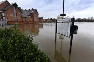
A flood warning for Ironbridge advised that river levels were rising at the Buildwas river gauge as a result of recent heavy rainfall.
"Flooding of property, roads and farmland is expected to continue. We expect flooding to affect properties on Ferry Road."
The predicted peak at Buildwas was 5m to 5.3m on Tuesday morning.
In Shrewsbury where there was a red flood warning for the Showground and the Quarry there was a peak at the Welsh Bridge of between 3.6m to 3.7m on Monday afternoon.
But the Environment Agency said that the further rainfall could push river levels in Shrewsbury and at Ironbridge higher again later in the week.
"We are closely monitoring the situation. Our incident response staff are checking defences and liaising with Local Authorities. Please plan driving routes to avoid low lying roads near rivers, which may be flooded and avoid contact with flood water."
In Bridgnorth the first predicted peak of 4 to 4.3m is Tuesday afternoon.
"A further peak of between 4.2 and 4.7m could be possible on Friday morning based upon this forecast rainfall."
Retired area manager for the Environment Agency, Dave Throup, said the latest rainfall is "definitely not what’s needed".
"With another warning for heavy rain across Wales and the Midlands we will see 15-30mm falling widely and up to 50mm locally. And that rain is falling on saturated ground and very full rivers.
"More flooding is inevitable."
However he said there was a bit of positive news.
"After the next few days there’s a good signal for much higher pressure sitting over or near the UK. It should be much drier, and probably colder," he said.