Met Office snow and ice warning raised to amber for parts of Shropshire
The Met Office has ramped up its warnings for snow and ice this week for parts of Shropshire, as it expects the county to be hit by a deluge of heavy snow on Thursday.
Watch more of our videos on Shots!
and live on Freeview channel 276
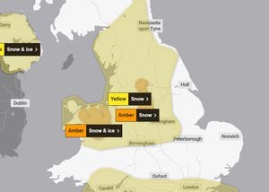
The amber alerts for snow and ice cover north Wales and north west Shropshire from 8am on Thursday to 3pm the same afternoon, and the Peak District and south Pennines from noon until 6pm.
The warnings follows a yellow weather warning for snow for most of Shropshire issued earlier this week for Thursday and Friday.
The Met Office said the new amber warnings mean snow and ice is expected to cause disruption across north Wales and northwest Shropshire.
There is a good chance that some rural communities could be temporarily cut off and travel delays on roads are likely, stranding some vehicles and passengers.
The Met Office also warned of possible power cuts and some delays and cancellations to rail travel are likely.
Untreated pavements and cycle paths are likely to be impassable with injuries from slips and falls likely on icy surfaces
A reported 10cm to 15cm of snow is forecast widely across both amber warning areas, with up to 25cm possible on higher ground.
National Highways travel advice issued
National Highways is encouraging motorists to plan their journeys and consider whether they are necessary with significant snow forecast to blanket northern and central regions in the early hours of Thursday.
The agency has also issued its own severe amber weather alert, which is based on different criteria and is focused on the potential impact to the strategic road network.
The Met Office have advised that snow will begin to fall in the northern regions in the early hours of Thursday. On lower ground this could turn to rain during the late morning, but higher routes across the Pennines could see snow fall throughout the day with very difficult driving conditions, particularly for HGVs and high-sided vehicles like caravans.
Up to 2.5cm of snow is predicted above 200m (including parts of the M6/M56 and M6/M62 intersections) and 10-15cm above 300m. This could peak with as much as 20cm of snow at the peak of the M62 and A628 Woodhead Pass.
A spokesperson said: "If you are considering travelling on these higher routes, please ask yourself if your journey is essential, and before setting off, please make sure you and your vehicle are prepared.
"HGV drivers are asked to consider avoiding parts of the road network with steeper than normal inclines, particularly in northern parts of the country. The predicted weather conditions could lead to vehicles becoming jack-knifed or stranded which can prevent gritting vehicles treating the road with salt or ploughing snow clear.
"With precipitation expected to turn lighter and patchier as it moves north, no more than 2-5 cm is expected on the A66 above 300 m. Patches of fog and high winds, gusting around 50 mph, could also make driving conditions treacherous on higher and more exposed routes."
National Highways, in conjunction with the Met Office, is strongly advising that travel in these areas is likely to be extended or even disrupted. Road users are advised to follow messages displayed on overhead signs and listen for radio updates. Further information can be found by visiting the Traffic England website or by calling the National Highways Information Line on: 0300 123 5000.
A fleet of 530 gritters are on hand for National Highways to call upon during sub-zero temperatures.
Amy Shaw, national network manager at National Highways, said: “Freezing conditions as we are expecting tonight bring hazards such as snow and ice, so take every possible step to understand your journey in advance and allow lots of extra time when travelling; prepare for the unexpected.
“When planning your journey, check the weather forecasts, and if weather conditions become challenging, adjust your driving behaviour and take extra care.”
National Highways is also reminding motorists to keep 'TRIP' in mind ahead of journeys – Top-up: oil, water, screenwash; Rest: rest every two hours; Inspect: Inspect tyres and lights and Prepare: check your route and the weather forecast.
Abigail Oakes, senior account manager at the Met Office, said: “We’re working closely with National Highways throughout the year to help people stay safe on the roads, and providing the best possible support for road users during periods of severe weather.
“All of the information we gather helps National Highways to inform road users about current road conditions whatever the weather. We also share information through channels including our website, third party travel providers – including sat nav companies – and local radio stations.”
Further information is available on the travelling in winter web page.
Flood alerts in place
There are currently no flood warnings in place for Shropshire, but there are three less serious flood alerts - for the Severn Vyrnwy confluence, the Tern and Perry catchments and the Upper Teme.
Live flood alert widget updates every 10 minutes:
A statement about the Severn Vyrnwy alert on the Environment Agency's flood checker page said roads and farmland were expected to start flooding. It said: "River levels are rising at the Llanymynech river gauge as a result of heavy rainfall.
"We expect flooding to affect low lying land and roads adjacent to the river from the Welsh border at Llawnt to Shrawardine near Shrewsbury. Other locations that may be affected include Llanymynech, Maesbrook and Melverley. Minor roads between Maesbrook, Melverley and Pentre start to flood.
"We expect river levels to remain high until Thursday. Further rainfall is forecast for the end of the week and river levels may rise again as a result.
"We are closely monitoring the situation. Our incident response staff are clearing weed screens.
"Please avoid using low lying footpaths near local watercourses and plan driving routes to avoid low lying roads near rivers, which may be flooded."