
Where to expect highest temperatures in Shropshire with latest heatwave on the way
Forecasters say another heatwave will hit Shropshire this week and it is set to last longer than the one that smashed temperature records earlier this summer.

The Met Office has predicted soaring temperatures from today through Friday, with sustained temperatures in the high 20s or even low 30s expected across the board.
Shropshire will already have heated up to the mid 20s today, with 26C predicted in Ludlow and Bridgnorth. Shrewsbury, Market Drayton and Telford are set to follow with temperatures of 25C, 24C and 23C respectively.
It will be slightly hotter again across Shropshire on Tuesday, expected to be highest at 27C in Ludlow at 7pm - then again at 29C on Wednesday afternoon.
Thursday will see the heat rise further still, with most of the county including Shrewsbury, Oswestry and Telford set to swelter at 28C or 29C, while Ludlow could even break the 30C barrier.
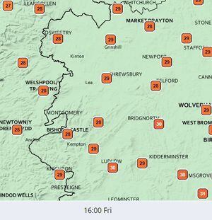
Ludlow and Bridgnorth could both experience 30C on Friday, while other towns including Newport and Whitchurch are expected to lag just behind at 29C.
Met Office meteorologist Tom Morgan said: “It will be a lot of sunshine for a vast majority of the UK and also temperatures rising day after day.
“Not everyone will initially see those sunny conditions, but towards the end of the week even Scotland and Northern Ireland will join the rest of the UK in having generally fine, sunny and very warm if not hot conditions.
“In terms of temperatures we’re looking at them build from 28C or 29C [Tuesday] to the low to mid 30s from Thursday onwards, so a fairly widespread heatwave developing across the UK this week.
“The peak of the temperatures look likely to occur on Friday or Saturday.”
Mr Morgan said the West Midlands and West Country could see the highest temperatures, with a maximum of around 35C predicted, but added this was still uncertain.
He added: “The heatwave we saw at the end of July, that was relatively short-lived and saw exceptionally high, record-breakingly high temperatures.
“We’re quite confident temperatures will not go as high as they did during July, but the difference is that this is going to be quite a prolonged period of temperatures in the low 30s, so it will be very notable nonetheless.
“Heatwave criteria are likely to be met across many parts of the UK and there will no doubt be some adverse impacts from heatwave exhaustion, dehydration and so on, so we do anticipate some potentially adverse effects to the NHS and more vulnerable people having heat-related problems through this period of time.”
The Met Office has urged people to follow precautions to avoid becoming overheated, including closing curtains and windows during the day and avoiding the midday sun.
It comes less than a month after a heatwave that saw two days of sweltering heat across the UK, including a new record temperature for the country recorded in the East Midlands.
The Met Office verified the new UK temperature record of 40.3C at Coningsby, Lincolnshire, seen on July 19 during the heatwave.
A new record for Wales of 37.1C at Hawarden Airport, Flintshire, on July 18, was also confirmed, as was a new record high daily minimum temperature for the country, of 24.5C at Aberporth on July 19.