95 Shropshire roads being resurfaced over next three months - see the full list
More than 90 stretches of road across Shropshire are to be fixed as part of a huge council roadworks project.
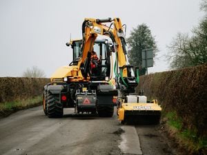
Shropshire Council has said that a total of 95 roads will be improved as part of its road dressing programme. These include roads in Shrewsbury, Minsterley, Westbury, Market Drayton, Whitchurch, Shawbury, Wem, Knockin, Oswestry, Bridgnorth, Claverley, Craven Arms, Clun, and Chirbury.
The work starts on May 3 and will continue until the end of July, and will range from from urban cul-de-sacs to major ‘A’ and ‘B’ roads.
Dean Carroll, Shropshire Council’s Cabinet member with responsibility for highways, said: “As well as improving and protecting our roads, this important programme of work plays a crucial role in helping to prevent potholes and other defects forming in the future.
"Pothole treatment is very much about prevention as well as cure and this is one important way that we can aim to prevent potholes forming next winter.”
The full list of roads being resurfaced between May and July is:
C2076 – Shotton Lane, Harmer Hill
B4387 – To Minsterley
A488 – District Boundary To Roundabout Minsterley
B4380 – Roman Road two Sections Either Side Of Longden Road
B4386 – B4386 From Yockelton Ford Heath Junction To Junction With A5
A458 – Cross Houses End 40mph To Cound Junction
A458 – From Atcham Road Jct To Start 60mph
B4394 – Norton Cross Roads To Walcot
B5062 – End 40mph Sundorne to Telford & Wrekin county boundary, Haughton
B4387 – B4387 – Halfway House to Westbury
C1061 – Montford School to Montford Bridge
C1061 – Grange Farm Junction to Preston Gubbals
A488 – Main Road, Pontesbury to Hanwood
B4380 – Holyhead Road, Montford Bridge to Urban Section
B4379 – End 40 Sheriffhales to Heath Hill Junction
U3067 – Alexandra Road
U2108 – Caldecott Crescent
U2129 – Chemistry, Whitchurch
U3011 – Glendon Close, Market Drayton
C2092 – Haywood Lane, Cheswardine
A41 – Southbound Dual, Heath Road Roundabout to Prees Heath Roundabout
C2075 – Yorton Station to A49
C2096 – Narrow Lane – Childs Ercall
U2109 – Sharps Drive, Whitchurch
U2130 – Smallbrook Road, Whitchurch
B5476 – Tilstock Rd, Whitchurch
U3034 – Victoria Road, Market Drayton
B5063 – Wem Road, Shawbury (30mph To A53)
B5063 – Wytheford Road, Shawbury
C2075 – Quarry View To 30mph Start A49 Preston Brockhurst Junction
B5395 – Old Malpas Road, Grindley Brook (A41 Junction to county boundary)
A49 – Preston Brockhurst Village
B5065 – Darliston to Crossroads Sandford
A41 – Tern Hill Roundabout to start of dual carriageway, Bletchley
B5063 – From A49 Rockall crossroads to Wem Road start
C2092 – Haywood Lane, Cheswardine (A529 At Woodseaves to canal)
B5063 – End of Urban Northwood to Ellesmere Road Wem
C1030 – Junction Lion Lane to Penley
C1049 – Spunhill crossroads to Colemere Farm
C1018 – Crosslanes to Plas Warren
B4397 – Marton Junction to Burlton crossroads 60mph to Pickhill
C2062 – Marton to Myddle Road (Myddle 30mph West to Myddle 30mph East)
B4580 – Castle Street
C1041 – Gamesters Lane, Sandford two sections classed as one site
U1050 – Drenewydd and Inglis Road, Park Hall
B5069 – Upper Church Street and Morda Road, Oswestry
U0340 – Vyrnwy Road, Oswestry
A495 – Whittington Road, Whittington 30mph start west
B4396 – From Nant Goch junction B4396–A495
C1011 – Cydygan Lane, Llansilin
C1013 – Sweeney Mountain Road (B5069 to Nuttree crossroads)
B4373 – North Gate
U7210 – Oldbury Wells
C4177 – C4177 – Pattingham Lane
B4363 – from A4117 to Kinlet Bank
B4194 – from Clogs Bank to Withybed Villa
B4363 – From A4117 to Kinlet Bank
B4194 – From Clogs Bank to Withybed Villa
C4267 – Heathton from Claverley to Six Ashes Road
B4555 – Chelmarsh to Covert Bridge and Ingram Lane
B4363 – Kinlet Bank Junction to Rays Bridge
B4363 – Priors Morr Bank
A442 – Telford & Wrekin district boundary to Sutton Maddock Island
A5 – Nty Boundary to Crackleybank crossroads
C4184 – County boundary South Home Farm Road – A464
A442 – Apley Green Gates
B5314 – Chatwell Lane – A41
B4555 – New Road
B4368 – Monkhopton to Aston Eyre
B4555 – Eardington to Hay Bridge
B4363 – Halfway House North to Manor Farm Lane
B4373 – Stocking Lane to School Lane
Monkhopton Junction Old School House – Lay-by Junction Farm to Junction B4368
B4176 – Littlegain access-county boundary
A454 – Royal Oak Island – Rudge Heath Road
C4249 – Oreton Bank 30mph section
B4364 – Lower Faintree – Lower Cockshutt
B4364 – Track Lower Cockshutt to Eudon Court Junction
B4386 – Little Worthen to Winsley Cottages
B4368 – Pedlars Rest to Diddlebury
B4368 – Diddlebury Village to Aston Munslow
B4368 – Clunsford Bridge – pedlars Rest
A4117 – Ludlow Road from Office Lane to Tenbury Road
B4362 – Station Road, Wooferton
C6269 – Tenbury Road rural section
C5140 – Stocton Road, Marton to B4386
B4386 – From Marton to Little Brockton rural section
A488 – Clun to Colstey Cottage
B4386 – from Monksfield Chirbury to Aylesford Bridge
A490 – Shiregrove Bridge – Chirbury
B4368 – Newcastle to 30mph Clun rural section
B4367 – Long Meadowend to Clungunford
B4364 – B4364 North of Westview to Stoke turn
B4385 – Red House to Little Brampton
A489 – From A488 Lydham to Eaton Junction
B4368 – Aston Munslow to New House Farm Junction
B4385 – Little Brompton county boundary to Brompton