Shrewsbury floods: Clean-up begins as aerial photos reveal scale of latest devastation
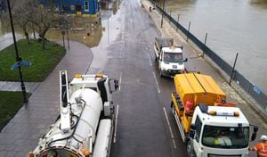
The floods clean-up is underway in Shrewsbury after the town was battered by its fourth disaster in three years.
Road sweeping and gully cleaning is taking place in several town centre locations as the River Severn settles down. It peaked yesterday at 5.15m, just short of the 5.25m all-time record.
Shropshire Council said on social media: "The big clean up begins! We have road sweeping and gully cleaning taking place at Wyle Cop, English Bridge, Castle Foregate, Smithfield Road and other areas in Shrewsbury as the river recedes.
"We will post information as soon as possible about road re-openings."

Levels are down nearly half a metre with new photos shared by the authority showing how much the water has cleared away from Smithfield Road and Wyle Cop. Shropshire Council also said it was using the opportunity to repair some of the potholes in Smithfield Road.
By mid-afternoon Castle Foregate and English Bridge had reopened. In an update at around 4.30pm Shropshire Council said: "The English Bridge Gyratory at Old Potts Way, Chester Street and Cross Street, along with Smithfield Road and Coleham are also being cleaned as water has receded - so they won't be far off either!"
A number of other road, remain closed - not just in Shrewsbury, but in Ironbridge and Bridgnorth too.
The lower river level also meant the Darwin shopping centre could reopen after closing its doors on Tuesday.
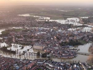
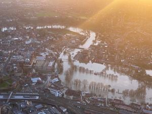
The clean-up operation comes as a series of aerial photos show the scale of the floods to hit the county town this year.
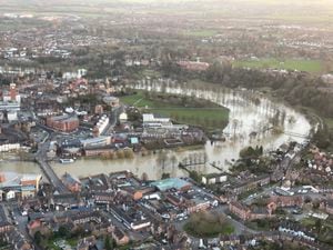
The pictures reveal how far the water reached, as it took over many low-lying roads, paths and parks near the River Severn. In some places the river only just passed underneath the arches of the Welsh and English Bridges as levels topped 5m.
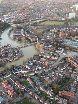
In some photos water can clearly be seen in the Coleham area of the town, while part of Abbey Foregate car park was also flooded on Tuesday evening.
Meanwhile another photo shows Frankwell Car Park, Smithfield Road and the showground completely submerged, with water on the roads approaching Shrewsbury railway station.
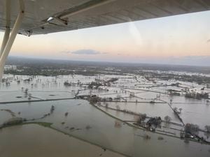
Just outside the town, the scale of the flooding was even more apparent with field after field disappearing from view underneath excess river water.
River levels in the Shrewsbury area peaked on Tuesday after causing more damage to those living and working in and around the Severn.