Shropshire Flood Alerts: Scores of warnings remain in place on Saturday following persistent downpours
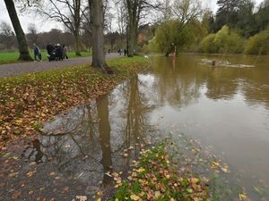
Scores of flood alerts remain in place on Saturday across Shropshire following heavy rain in recent days.
The Environment Agency warnings show that eight flood alerts are still in place across Shropshire this morning - Saturday, February 7.
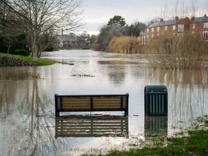
Flood alerts are the second most serious warning issued by the EA, with people advised that 'flooding is possible', and urged to make preparations in the eventuality it does materialise.
It comes after a 40 hour weather warning for rain covering Shropshire elapsed on Friday.
Alerts remaining include an overall alert for the River Severn, covering large parts of the county, as well as others in North and South Shropshire.
River Severn: Flooding may affect low lying land and roads adjacent to the river from Shrewsbury to Upper Arley. Locations that may be affected are White Abbey, Coalbrookdale, Ironbridge and Bridgnorth.
Severn Vyrnwy Confluence: Flooding may affect low lying land and roads adjacent to the river from the Welsh border at Llawnt to Shrawardine near Shrewsbury. Other locations that may be affected include Llanymynech, Maesbrook and Melverley. Roads between Maesbrook, Melverley and Pentre start to flood.
Ledwyche Brook and River Rea: Flooding may affect low lying land and roads adjacent to the Ledyche Brook and River Rea. Locations that may be affected include Cleobury Mortimer, Neen Sollars and Caynham.
River Worfe: Flooding may affect low lying land and roads adjacent to the river from Crackley Bank to Bridgnorth. Other locations that may be affected include Ryton and Burcote. Water is rising in the drains at Worfield.
Tern and Perry Catchments: Flooding may affect low lying land and roads adjacent to the river from Wolverley to Newport. Other locations that may be affected include Market Drayton, Wem, and Rodington.
Upper Teme: Flooding may affect low lying land and roads adjacent the River Teme, River Onny and River Corve and their tributaries. Locations that may be affected include Bishops Castle, Church Stretton, Knighton and Ludlow.
Rea Brook and Cound Brook: Flooding may affect low lying land and roads adjacent to the river from Shrewsbury to Church Stretton. Other locations that may be affected include Minsterley, Pontesford and Harrington. The floodplain has started to fill adjacent to the Hookagate gauge on the left bank.
River Dee catchment in England from Whitchurch to Chester: Locations most affected will be low lying land and roads around the River Dee at Shocklach, Farndon, Handley, Lower Kinnerton, Chester and Puddington.
The current River Severn peaks are predicted as 5.5m to 5.6m at Crew Green today - Saturday, February 7, and 4.0m to 4.3m at Buildwas on Sunday, February 8.