
Met office issues 27-hour weather warning for West Midlands and Shropshire
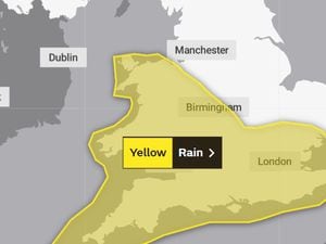
A 27-hour weather warning has been issued for the West Midlands, Shropshire and Mid Wales.
Heavy rain is set to lash Britons over the next few days while temperatures could drop below freezing as a cold snap moves in.
A yellow warning for rain will be in place from 9pm on Thursday until midnight on Friday, the Met Office confirmed.
Forecasters say difficult driving conditions are expected due to surface water and spray on faster routes.
They added spray and flooding on the roads would probably make journey times longer, with some flooding of homes and business likely. Bus and train services may be affected with journey times taking longer it warns.
A Met Office spokesman said: "Occasionally heavy rain will reach southwest Britain Thursday evening, then spread across much of England and Wales on Friday.
"Spray and flooding on roads probably making journey times longer.
"Flooding of a few homes and businesses is likely. Bus and train services probably affected with journey times taking longer."
Meanwhile, temperatures are set to drop from the unseasonably warm early October weather, leading to potential snow over the mountains of Scotland as well as widespread overnight frost across the UK.
It comes after the warmest October day in five years was recorded on Sunday, as temperatures hit 25.8C in Kew Gardens, west London.
Met Office spokesman Grahame Madge said: “On Wednesday night, there may potentially be some frosts and much colder than average conditions, which might be a shock for northern parts of Britain because we’ve had this relatively warm air across most of the UK.
“There will be an increasing tendency towards cooler conditions, however in the southern parts of England and Wales we’ve got the prospect of heavy rain coming in.
“We’re saying there is a significant rain warning from 9pm on Thursday through to midnight on Friday, and we can expect 20 to 30mm in some places in a couple of hours. Even up to 50, 60 or possibly up to 70mm across the high ground of Wales, these are significant amounts.
“Once that warning expires, we’ve got another shift in our weather pattern where we’re getting a more northerly flow coming in.
“That will introduce much cooler conditions, six degrees below average, which given the fact a few days ago we were talking about conditions six or so degrees above average, will feel like a marked contrast.
“We’ve got the prospect on Saturday of early frost in some sheltered northern areas, even some snowfall over the Scottish mountains.”


