Flood alerts issued across Shropshire as River Severn levels rise
Residents have been placed on alert that flooding is possible in areas of Shropshire due to rising river levels.
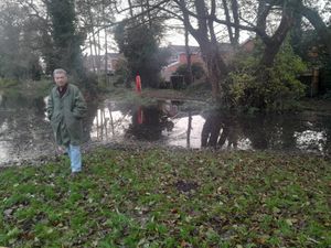
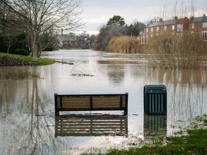
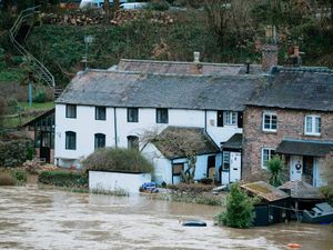
Flood alerts have been issued for the River Severn in Shropshire, covering Shrewsbury, Coalbrookedale, Ironbridge and Bridgnorth, as well as for the Severn Vyrnwy confluence, affecting areas including Llanymynech, Maesbrook and Melverley.
The Environment Agency said flooding may affect low lying land and roads adjacent to the river from Shrewsbury to Upper Arley, and from the Welsh border at Llawnt to Shrawardine near Shrewsbury.
The banks of the River Severn banks at White Abbey are reported to be full, and floodplains may also be filling at the Hayes Basin.
The river was predicted to peak at between 4.4 metres and 4.7m at the Crew Green river gauge near Shrewsbury, between 4.4m and 4.9m at the Montford gauge, also near Shrewsbury, and between 2.2m and 2.6m at the Welsh Bridge in the county town.
Meanwhile, the Environment Agency has warned that roads between Maesbrook, Melverley and Pentre may begin to flood.
At Llanymynech, the river was predicted to peak at around 4m this morning, and at between 3.4m and 3.6m at the Cae Howel gauge near Oswestry.
The Environment Agency said: "Forecast rising river levels today may lead to flooding. Flooding is possible from November 12.
"We are closely monitoring the situation. Take care and avoid walking, cycling or driving through flood water and monitor local water levels and weather conditions.
"Avoid low lying roads near rivers, which may be flooded and monitor local water levels and weather conditions."
The Environment Agency said it would be updating its alerts by this evening or as the situation changes.
Further information can be found here.