
Florida braces for major damage after Hurricane Ian slams Cuba with 125mph winds
The storm is forecast to strengthen over the Gulf of Mexico as it approaches Florida’s south-west coast.
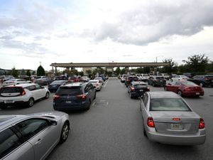
Hurricane Ian has torn into western Cuba as a major hurricane, with nothing to stop it from intensifying into a Category 4 storm before it hits Florida, where officials ordered 2.5 million people to evacuate before it crashes ashore on Wednesday.
Ian made landfall in Cuba’s Pinar del Rio province, where officials set up 55 shelters, evacuated 50,000 people, rushed in emergency personnel and took steps to protect crops in Cuba’s main tobacco-growing region.
The US National Hurricane Centre said “significant wind and storm surge impacts” were occurring on Tuesday in western Cuba, with top winds of 125mph and as much as 14ft of storm surge predicted along the coast.
Ian is forecast to strengthen over warm Gulf of Mexico waters, reaching top winds of 140mph as it approaches the Florida’s south-west coast. Tropical storm-force winds were expected across the southern peninsula late on Tuesday, reaching hurricane force on Wednesday morning.
Florida governor Ron DeSantis said an estimated 2.5 million people were under evacuation orders.
He cautioned that damage is expected across a wide area regardless of where Ian makes landfall. He urged people to prepare for power outages, and to get out of its way.
“When you have 5ft to 10ft of storm surge, that is not something you want to be a part of,” he said. “And Mother Nature is a very fearsome adversary.”
The hurricane centre expanded its hurricane warning to include Bonita Beach north through Tampa Bay to the Anclote River. Fort Myers is in the hurricane zone, and Tampa and St Petersburg could get their first direct hit by a major hurricane since 1921.
While Ian’s centre passed over western Cuba, with tropical storm force winds extending outward 115 miles, Cuba’s capital was getting rain and strong gusts. Havana’s residents openly worried about flooding ahead of the storm, with workers unclogging storm drains and fishermen taking their boats out of the water.
Ian’s forward movement is expected to slow over the Gulf, enabling the hurricane to grow wider and stronger before it brings punishing wind and water to Florida’s west coast.
Forecasters said the surge of ocean water could reach 10ft if it peaks at high tide. Rainfall could total 16in with as much as 24in in isolated areas.
As many as 300,000 people may be evacuated from low-lying areas in Hillsborough County alone, county administrator Bonnie Wise said, with schools and other locations opening as shelters.

Lee County on Florida’s south-west coast issued mandatory evacuations early on Tuesday for low-lying areas including Fort Myers Beach, Sanibel and Bonita Beach, where about 250,000 people live, after forecasters expanded the hurricane warning area.
Mr DeSantis declared a Florida-wide emergency and mobilised 5,000 Florida National Guard troops, with another 2,000 on standby in neighbouring states.
President Joe Biden also declared an emergency, authorising the Department of Homeland Security and the Federal Emergency Management Agency (Fema) to co-ordinate disaster relief and provide assistance to protect lives and property.
Fema has strategically positioned generators, millions of meals and millions of litres of water, White House press secretary Karine Jean-Pierre said.
Playing it safe, Nasa rolled its moon rocket from a launch pad to its Kennedy Space Centre hangar, adding weeks of delay to a test flight; airports in Tampa and St Petersburg announced they would close; and the Tampa Bay Buccaneers NFL side said they would relocate operations to the Miami area on Tuesday in preparation for next weekend’s game.
Damaging winds and flooding are expected across the entire peninsula as Ian moves north, reaching into Georgia, South Carolina and other parts of the south-eastern US.